Kimito geodata
Kimito (Southwest Finland) is a seat of a third-order administrative division; located in Finland in Europe/Helsinki (GMT+3) time zone. With population of 3,287 people, there are 282 cities with bigger population in this country. Compared to other cities in Finland, 97.2% of cities are located further ↑North; 79.5% of cities are located further →East and 82.5% of cities have higher elevation than Kimito. Note1


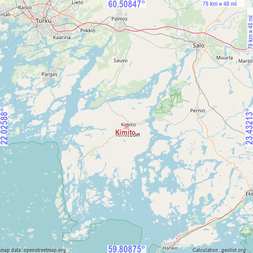
Kimito GPS coordinates[2]
60° 9' 37.692" North, 22° 43' 44.4" East
| Map corner | latitude | longitude |
|---|---|---|
| Upper-left | 60.50847°, | 22.02588° |
| Center: | 60.16047°, | 22.729° |
| Lower-right: | 59.80875°, | 23.43213° |
| Map W x H: | 77.8×77.8 km | = 48.3×48.3mi |
| max Lat: | 69.90864° ⇑97.2% North |
| Kimito: | 60.16047° |
| min Lat: | ⇓2.8% South 59.83333° |
| min Long | Kimito | max Long |
| 21.2° | 22.729° | 30.93276° |
| W 20.5%⇐ | ⇒79.5% E |
Elevation
Elevation of Kimito is 17 m = 56 ft, and this is 60.1 m = 197 ft below average elevation for this country.
| Max E: |
299 m = 981 ft | 82.5% |
| Avg. | 77.1 m = 253 ft | |
| Kimito | 17 m = 56 ft | |
Min E: |
1 m = 3 ft | 17.5% |
See also: Finland elevation on elevation.city.
Geographical zone
Kimito is located in North temperate zone (between Tropic of Cancer and the Arctic Circle). Distance of this North polar circle is 712 km =442.4 mi to North.| Distance of | km | miles | from Kimito |
|---|---|---|---|
| North Pole | 3317.8 | 2061.6 | to North |
| Arctic Circle | 712 | 442.4 | to North |
| Tropic Cancer | 4083.3 | 2537.2 | to South |
| Equator | 6689.2 | 4156.5 | to South |


Nearby cities:
15 places around Kimito: (largest is in red/bold)
• Dragsfjärd
17.1 km =10.6 mi,  232°
232°
• Halikko
33 km =20.5 mi,  36°
36°
• Hanko
38.4 km =23.9 mi,  161°
161°
• Kaarina
33.9 km =21.1 mi,  324°
324°
• Muurla
37.1 km =23.1 mi,  55°
55°
• Paimio
33 km =20.5 mi,  355°
355°
• Pargas
28.7 km =17.8 mi,  304°
304°
• Perniö
22.8 km =14.2 mi,  78°
78°
• Piikkiö
31.6 km =19.6 mi,  338°
338°
• Salo
33.3 km =20.7 mi, 41°
• Sauvo
20.4 km =12.7 mi,  354°
354°
• Särkisalo
13.3 km =8.3 mi,  112°
112°
• Turku
41.1 km =25.5 mi, 321°
• Västanfjärd
12.5 km =7.8 mi,  191°
191°
• Väståboland
28.3 km =17.6 mi, 303°
Sources, notices
• [Note1] Compared only with cities in Finland existing in our database
• [Src1] Map data: © OpenStreetMap contributors (CC-BY-SA)
• [Src2] Other city data from geonames.org with taken over terms of usage.
• [Src3] Geographical zone / Annual Mean Temperature by Robert A. Rohde @ Wikipedia
