Sahalahti geodata
Sahalahti (Pirkanmaa) is a populated place; located in Finland in Europe/Helsinki (GMT+3) time zone. With population of 2,141 people, there are 343 cities with bigger population in this country. Compared to other cities in Finland, 57.1% of cities are located further ↑North; 56.6% of cities are located further →East and 65% of cities have lower elevation than Sahalahti. Note1


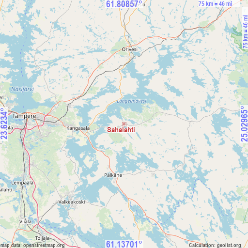
Sahalahti GPS coordinates[2]
61° 28' 28.56" North, 24° 19' 35.472" East
| Map corner | latitude | longitude |
|---|---|---|
| Upper-left | 61.80857°, | 23.6234° |
| Center: | 61.4746°, | 24.32652° |
| Lower-right: | 61.13701°, | 25.02965° |
| Map W x H: | 74.7×74.7 km | = 46.4×46.4mi |
| max Lat: | 69.90864° ⇑57.1% North |
| Sahalahti: | 61.4746° |
| min Lat: | ⇓42.9% South 59.83333° |
| min Long | Sahalahti | max Long |
| 21.2° | 24.32652° | 30.93276° |
| W 43.4%⇐ | ⇒56.6% E |
Elevation
Elevation of Sahalahti is 101 m = 331 ft, and this is 23.9 m = 78 ft above average elevation for this country.
| Max E: |
299 m = 981 ft | 35% |
| Sahalahti | 101 m 331 ft | |
| Avg. | 77.1 m = 253 ft | |
Min E: |
1 m = 3 ft | 65% |
See also: Finland elevation on elevation.city.
Geographical zone
Sahalahti is located in North temperate zone (between Tropic of Cancer and the Arctic Circle). Distance of this North polar circle is 565.8 km =351.6 mi to North.| Distance of | km | miles | from Sahalahti |
|---|---|---|---|
| North Pole | 3171.7 | 1970.8 | to North |
| Arctic Circle | 565.8 | 351.6 | to North |
| Tropic Cancer | 4229.4 | 2628 | to South |
| Equator | 6835.3 | 4247.3 | to South |


Nearby cities:
15 places around Sahalahti: (largest is in red/bold)
• Akaa
42.1 km =26.2 mi,  215°
215°
• Hauho
35.9 km =22.3 mi,  159°
159°
• Juupajoki
36.1 km =22.4 mi,  3°
3°
• Kangasala
13.4 km =8.3 mi,  264°
264°
• Kuhmalahti
13.1 km =8.1 mi,  77°
77°
• Lempäälä
35.4 km =22 mi,  240°
240°
• Luopioinen
22 km =13.7 mi,  124°
124°
• Orivesi
22.6 km =14 mi, 4°
• Pirkkala
36.9 km =22.9 mi,  267°
267°
• Pälkäne
15.9 km =9.9 mi,  190°
190°
• Tampere
28.8 km =17.9 mi,  275°
275°
• Valkeakoski
28.2 km =17.5 mi,  213°
213°
• Vesilahti
41.7 km =25.9 mi,  245°
245°
• Viiala
41.9 km =26 mi,  225°
225°
• Ylöjärvi
39.8 km =24.7 mi, 283°
Sources, notices
• [Note1] Compared only with cities in Finland existing in our database
• [Src1] Map data: © OpenStreetMap contributors (CC-BY-SA)
• [Src2] Other city data from geonames.org with taken over terms of usage.
• [Src3] Geographical zone / Annual Mean Temperature by Robert A. Rohde @ Wikipedia
