Pälkäne geodata
Pälkäne (Pirkanmaa) is a seat of a third-order administrative division; located in Finland in Europe/Helsinki (GMT+3) time zone. With population of 4,262 people, there are 240 cities with bigger population in this country. Compared to other cities in Finland, 60% of cities are located further ↑North; 57.5% of cities are located further →East and 58.8% of cities have lower elevation than Pälkäne. Note1


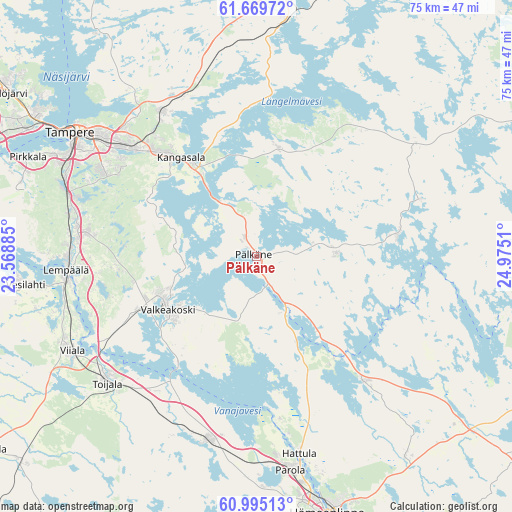
Pälkäne GPS coordinates[2]
61° 20' 3.264" North, 24° 16' 19.092" East
| Map corner | latitude | longitude |
|---|---|---|
| Upper-left | 61.66972°, | 23.56885° |
| Center: | 61.33424°, | 24.27197° |
| Lower-right: | 60.99513°, | 24.9751° |
| Map W x H: | 75×75 km | = 46.6×46.6mi |
| max Lat: | 69.90864° ⇑60% North |
| Pälkäne: | 61.33424° |
| min Lat: | ⇓40% South 59.83333° |
| min Long | Pälkäne | max Long |
| 21.2° | 24.27197° | 30.93276° |
| W 42.5%⇐ | ⇒57.5% E |
Elevation
Elevation of Pälkäne is 93 m = 305 ft, and this is 15.9 m = 52 ft above average elevation for this country.
| Max E: |
299 m = 981 ft | 41.2% |
| Pälkäne | 93 m 305 ft | |
| Avg. | 77.1 m = 253 ft | |
Min E: |
1 m = 3 ft | 58.8% |
See also: Finland elevation on elevation.city.
Geographical zone
Pälkäne is located in North temperate zone (between Tropic of Cancer and the Arctic Circle). Distance of this North polar circle is 581.4 km =361.3 mi to North.| Distance of | km | miles | from Pälkäne |
|---|---|---|---|
| North Pole | 3187.3 | 1980.5 | to North |
| Arctic Circle | 581.4 | 361.3 | to North |
| Tropic Cancer | 4213.8 | 2618.3 | to South |
| Equator | 6819.7 | 4237.6 | to South |


Nearby cities:
15 places around Pälkäne: (largest is in red/bold)
• Akaa
28.6 km =17.8 mi,  229°
229°
• Hauho
23.8 km =14.8 mi,  139°
139°
• Kalvola
27.2 km =16.9 mi,  197°
197°
• Kangasala
17.8 km =11.1 mi,  324°
324°
• Kuhmalahti
24.2 km =15 mi,  40°
40°
• Lempäälä
27.9 km =17.3 mi,  265°
265°
• Luopioinen
21.3 km =13.2 mi,  81°
81°
• Parola
32.3 km =20.1 mi,  172°
172°
• Sahalahti
15.9 km =9.9 mi,  10°
10°
• Tampere
31.6 km =19.6 mi,  305°
305°
• Toijala
29.7 km =18.5 mi, 231°
• Tuulos
34.9 km =21.7 mi,  125°
125°
• Valkeakoski
15 km =9.3 mi,  238°
238°
• Vesilahti
35 km =21.7 mi, 266°
• Viiala
30.3 km =18.8 mi, 242°
Sources, notices
• [Note1] Compared only with cities in Finland existing in our database
• [Src1] Map data: © OpenStreetMap contributors (CC-BY-SA)
• [Src2] Other city data from geonames.org with taken over terms of usage.
• [Src3] Geographical zone / Annual Mean Temperature by Robert A. Rohde @ Wikipedia
