Pyhäntä geodata
Pyhäntä (Northern Ostrobothnia) is a seat of a third-order administrative division; located in Finland in Europe/Helsinki (GMT+3) time zone. With population of 1,779 people, there are 372 cities with bigger population in this country. Compared to other cities in Finland, 85.5% of cities are located further ↓South; 73.5% of cities are located further ←West and 87.2% of cities have lower elevation than Pyhäntä. Note1
Administrative division(s):
- Level 1: Northern Ostrobothnia
- Level 2: Haapavesi-Siikalatva
- Level 3: Pyhäntä


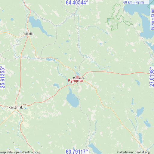
Pyhäntä GPS coordinates[2]
64° 6' 0" North, 26° 19' 0.012" East
| Map corner | latitude | longitude |
|---|---|---|
| Upper-left | 64.40544°, | 25.61355° |
| Center: | 64.1°, | 26.31667° |
| Lower-right: | 63.79117°, | 27.0198° |
| Map W x H: | 68.3×68.3 km | = 42.4×42.4mi |
| max Lat: | 69.90864° ⇑14.5% North |
| Pyhäntä: | 64.1° |
| min Lat: | ⇓85.5% South 59.83333° |
| min Long | Pyhäntä | max Long |
| 21.2° | 26.31667° | 30.93276° |
| W 73.5%⇐ | ⇒26.5% E |
Elevation
Elevation of Pyhäntä is 133 m = 436 ft, and this is 55.9 m = 183 ft above average elevation for this country.
| Max E: |
299 m = 981 ft | 12.8% |
| Pyhäntä | 133 m 436 ft | |
| Avg. | 77.1 m = 253 ft | |
Min E: |
1 m = 3 ft | 87.2% |
See also: Finland elevation on elevation.city.
Geographical zone
Pyhäntä is located in North temperate zone (between Tropic of Cancer and the Arctic Circle). Distance of this North polar circle is 273.9 km =170.2 mi to North.| Distance of | km | miles | from Pyhäntä |
|---|---|---|---|
| North Pole | 2879.8 | 1789.4 | to North |
| Arctic Circle | 273.9 | 170.2 | to North |
| Tropic Cancer | 4521.3 | 2809.4 | to South |
| Equator | 7127.3 | 4428.7 | to South |


Nearby cities:
15 places around Pyhäntä: (largest is in red/bold)
• Haapajärvi
61.8 km =38.4 mi,  231°
231°
• Haapavesi
46.3 km =28.8 mi,  274°
274°
• Kajaani
69.9 km =43.4 mi,  78°
78°
• Kestilä
27.9 km =17.3 mi,  356°
356°
• Kiuruvesi
52.1 km =32.4 mi,  163°
163°
• Kärsämäki
30.6 km =19 mi,  241°
241°
• Nivala
68.9 km =42.8 mi,  252°
252°
• Piippola
18.5 km =11.5 mi,  293°
293°
• Pulkkila
28.6 km =17.8 mi,  310°
310°
• Pyhäjärvi
52.3 km =32.5 mi,  202°
202°
• Pyhäsalmi
49.1 km =30.5 mi, 199°
• Rantsila
55 km =34.2 mi,  325°
325°
• Vaala
57.5 km =35.7 mi,  25°
25°
• Vieremä
51.8 km =32.2 mi,  138°
138°
• Vuolijoki
34.3 km =21.3 mi,  73°
73°
Sources, notices
• [Note1] Compared only with cities in Finland existing in our database
• [Src1] Map data: © OpenStreetMap contributors (CC-BY-SA)
• [Src2] Other city data from geonames.org with taken over terms of usage.
• [Src3] Geographical zone / Annual Mean Temperature by Robert A. Rohde @ Wikipedia
