Rantsila geodata
Rantsila (Northern Ostrobothnia) is a populated place; located in Finland in Europe/Helsinki (GMT+3) time zone. With population of 2,048 people, there are 353 cities with bigger population in this country. Compared to other cities in Finland, 89.3% of cities are located further ↓South; 65.6% of cities are located further ←West and 58.8% of cities have higher elevation than Rantsila. Note1
Administrative division(s):
- Level 1: Northern Ostrobothnia
- Level 2: Haapavesi-Siikalatva
- Level 3: Siikalatva


Rantsila GPS coordinates[2]
64° 30' 22.068" North, 25° 39' 52.164" East
| Map corner | latitude | longitude |
|---|---|---|
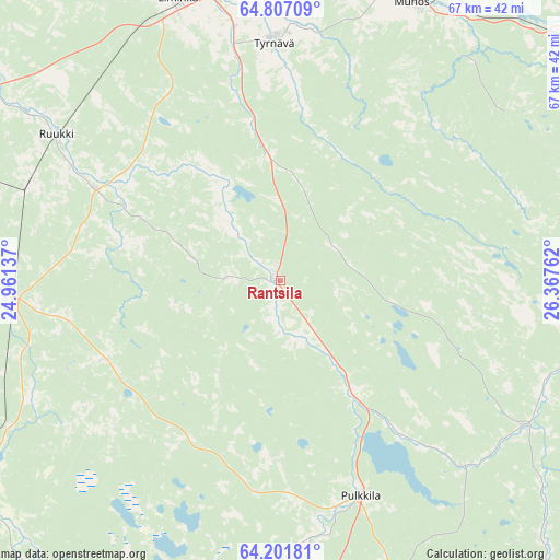
| Upper-left | 64.80709°, | 24.96137° |
| Center: | 64.50613°, | 25.66449° |
| Lower-right: | 64.20181°, | 26.36762° |
| Map W x H: | 67.3×67.3 km | = 41.8×41.8mi |
| max Lat: | 69.90864° ⇑10.7% North |
| Rantsila: | 64.50613° |
| min Lat: | ⇓89.3% South 59.83333° |
| min Long | Rantsila | max Long |
| 21.2° | 25.66449° | 30.93276° |
| W 65.6%⇐ | ⇒34.4% E |
Elevation
Elevation of Rantsila is 64 m = 210 ft, and this is 13.1 m = 43 ft below average elevation for this country.
| Max E: |
299 m = 981 ft | 58.8% |
| Avg. | 77.1 m = 253 ft | |
| Rantsila | 64 m = 210 ft | |
Min E: |
1 m = 3 ft | 41.2% |
See also: Finland elevation on elevation.city.
Geographical zone
Rantsila is located in North temperate zone (between Tropic of Cancer and the Arctic Circle). Distance of this North polar circle is 228.8 km =142.2 mi to North.| Distance of | km | miles | from Rantsila |
|---|---|---|---|
| North Pole | 2834.7 | 1761.4 | to North |
| Arctic Circle | 228.8 | 142.2 | to North |
| Tropic Cancer | 4566.5 | 2837.5 | to South |
| Equator | 7172.4 | 4456.7 | to South |


Nearby cities:
15 places around Rantsila: (largest is in red/bold)
• Haapavesi
43.9 km =27.3 mi,  199°
199°
• Kempele
45.9 km =28.5 mi,  350°
350°
• Kestilä
34.2 km =21.3 mi,  120°
120°
• Liminka
35.8 km =22.2 mi,  340°
340°
• Lumijoki
43.3 km =26.9 mi,  328°
328°
• Muhos
35.6 km =22.1 mi,  35°
35°
• Muhos
37 km =23 mi,  24°
24°
• Oulainen
49.4 km =30.7 mi,  237°
237°
• Oulunsalo
49.1 km =30.5 mi, 345°
• Piippola
40.5 km =25.2 mi,  158°
158°
• Pulkkila
28.3 km =17.6 mi, 159°
• Ruukki
32.3 km =20.1 mi,  303°
303°
• Tyrnävä
28.8 km =17.9 mi,  358°
358°
• Utajärvi
43.7 km =27.2 mi,  51°
51°
• Vihanti
32.3 km =20.1 mi,  265°
265°
Sources, notices
• [Note1] Compared only with cities in Finland existing in our database
• [Src1] Map data: © OpenStreetMap contributors (CC-BY-SA)
• [Src2] Other city data from geonames.org with taken over terms of usage.
• [Src3] Geographical zone / Annual Mean Temperature by Robert A. Rohde @ Wikipedia
