Puumala geodata
Puumala (South Savo) is a seat of a third-order administrative division; located in Finland in Europe/Helsinki (GMT+3) time zone. With population of 2,693 people, there are 315 cities with bigger population in this country. Compared to other cities in Finland, 55.3% of cities are located further ↑North; 89.3% of cities are located further ←West and 72.9% of cities have lower elevation than Puumala. Note1


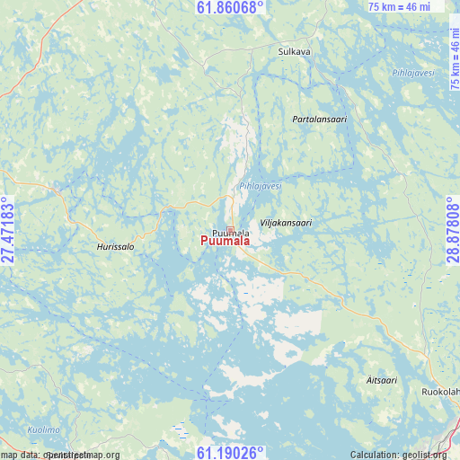
Puumala GPS coordinates[2]
61° 31' 38.208" North, 28° 10' 29.82" East
| Map corner | latitude | longitude |
|---|---|---|
| Upper-left | 61.86068°, | 27.47183° |
| Center: | 61.52728°, | 28.17495° |
| Lower-right: | 61.19026°, | 28.87808° |
| Map W x H: | 74.5×74.5 km | = 46.3×46.3mi |
| max Lat: | 69.90864° ⇑55.3% North |
| Puumala: | 61.52728° |
| min Lat: | ⇓44.7% South 59.83333° |
| min Long | Puumala | max Long |
| 21.2° | 28.17495° | 30.93276° |
| W 89.3%⇐ | ⇒10.7% E |
Elevation
Elevation of Puumala is 109 m = 358 ft, and this is 31.9 m = 105 ft above average elevation for this country.
| Max E: |
299 m = 981 ft | 27.1% |
| Puumala | 109 m 358 ft | |
| Avg. | 77.1 m = 253 ft | |
Min E: |
1 m = 3 ft | 72.9% |
See also: Finland elevation on elevation.city.
Geographical zone
Puumala is located in North temperate zone (between Tropic of Cancer and the Arctic Circle). Distance of this North polar circle is 560 km =348 mi to North.| Distance of | km | miles | from Puumala |
|---|---|---|---|
| North Pole | 3165.9 | 1967.2 | to North |
| Arctic Circle | 560 | 348 | to North |
| Tropic Cancer | 4235.3 | 2631.7 | to South |
| Equator | 6841.2 | 4250.9 | to South |


Nearby cities:
15 places around Puumala: (largest is in red/bold)
• Imatra
50.1 km =31.1 mi,  142°
142°
• Joutseno
48.9 km =30.4 mi,  158°
158°
• Juva
44.8 km =27.8 mi,  337°
337°
• Lappeenranta
52.1 km =32.4 mi,  179°
179°
• Lemi
55.3 km =34.4 mi,  200°
200°
• Mikkeli
51 km =31.7 mi,  290°
290°
• Rantasalmi
60.3 km =37.5 mi,  6°
6°
• Rautjärvi
63.2 km =39.3 mi,  99°
99°
• Ristiina
49.3 km =30.6 mi,  267°
267°
• Ruokolahti
44.3 km =27.5 mi,  127°
127°
• Savitaipale
44.3 km =27.5 mi,  214°
214°
• Savonlinna
53.2 km =33.1 mi,  44°
44°
• Sulkava
30.7 km =19.1 mi,  19°
19°
• Suomenniemi
44.5 km =27.7 mi,  240°
240°
• Taipalsaari
42.5 km =26.4 mi,  189°
189°
Sources, notices
• [Note1] Compared only with cities in Finland existing in our database
• [Src1] Map data: © OpenStreetMap contributors (CC-BY-SA)
• [Src2] Other city data from geonames.org with taken over terms of usage.
• [Src3] Geographical zone / Annual Mean Temperature by Robert A. Rohde @ Wikipedia
