Rantasalmi geodata
Rantasalmi (South Savo) is a seat of a third-order administrative division; located in Finland in Europe/Helsinki (GMT+3) time zone. With population of 4,443 people, there are 232 cities with bigger population in this country. Compared to other cities in Finland, 53.8% of cities are located further ↓South; 90.6% of cities are located further ←West and 60% of cities have higher elevation than Rantasalmi. Note1


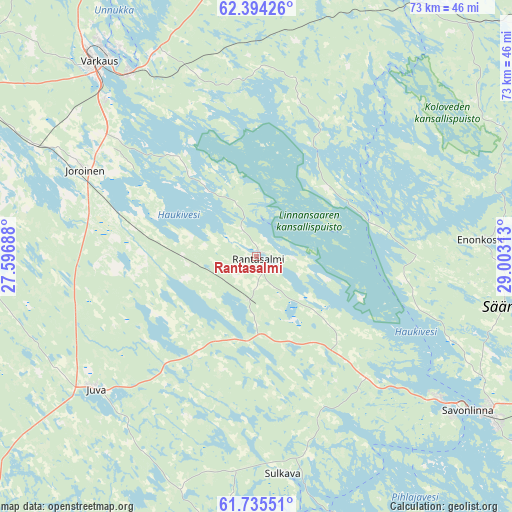
Rantasalmi GPS coordinates[2]
62° 4' 0.012" North, 28° 18' 0" East
| Map corner | latitude | longitude |
|---|---|---|
| Upper-left | 62.39426°, | 27.59688° |
| Center: | 62.06667°, | 28.3° |
| Lower-right: | 61.73551°, | 29.00313° |
| Map W x H: | 73.2×73.2 km | = 45.5×45.5mi |
| max Lat: | 69.90864° ⇑46.2% North |
| Rantasalmi: | 62.06667° |
| min Lat: | ⇓53.8% South 59.83333° |
| min Long | Rantasalmi | max Long |
| 21.2° | 28.3° | 30.93276° |
| W 90.6%⇐ | ⇒9.4% E |
Elevation
Elevation of Rantasalmi is 62 m = 203 ft, and this is 15.1 m = 50 ft below average elevation for this country.
| Max E: |
299 m = 981 ft | 60% |
| Avg. | 77.1 m = 253 ft | |
| Rantasalmi | 62 m = 203 ft | |
Min E: |
1 m = 3 ft | 40% |
See also: Finland elevation on elevation.city.
Geographical zone
Rantasalmi is located in North temperate zone (between Tropic of Cancer and the Arctic Circle). Distance of this North polar circle is 500 km =310.7 mi to North.| Distance of | km | miles | from Rantasalmi |
|---|---|---|---|
| North Pole | 3105.9 | 1929.9 | to North |
| Arctic Circle | 500 | 310.7 | to North |
| Tropic Cancer | 4295.2 | 2668.9 | to South |
| Equator | 6901.2 | 4288.2 | to South |


Nearby cities:
15 places around Rantasalmi: (largest is in red/bold)
• Enonkoski
33 km =20.5 mi,  86°
86°
• Haukivuori
56.6 km =35.2 mi,  264°
264°
• Heinävesi
43.6 km =27.1 mi,  20°
20°
• Joroinen
27.3 km =17 mi,  296°
296°
• Juva
29.9 km =18.6 mi,  231°
231°
• Jäppilä
56.8 km =35.3 mi,  307°
307°
• Kangaslampi
25.6 km =15.9 mi,  354°
354°
• Kerimäki
54.1 km =33.6 mi,  108°
108°
• Leppävirta
54.2 km =33.7 mi,  330°
330°
• Puumala
60.3 km =37.5 mi,  186°
186°
• Savonlinna
37.4 km =23.2 mi,  125°
125°
• Savonranta
48.6 km =30.2 mi,  74°
74°
• Sulkava
31.3 km =19.4 mi,  173°
173°
• Varkaus
35.4 km =22 mi,  321°
321°
• Virtasalmi
44.1 km =27.4 mi,  278°
278°
Sources, notices
• [Note1] Compared only with cities in Finland existing in our database
• [Src1] Map data: © OpenStreetMap contributors (CC-BY-SA)
• [Src2] Other city data from geonames.org with taken over terms of usage.
• [Src3] Geographical zone / Annual Mean Temperature by Robert A. Rohde @ Wikipedia
