Muhos geodata
Muhos (Northern Ostrobothnia) is a seat of a third-order administrative division; located in Finland in Europe/Helsinki (GMT+3) time zone. In our database, there are 443 cities with bigger population. Compared to other cities in Finland, 90.8% of cities are located further ↓South; 72% of cities are located further ←West and 60% of cities have higher elevation than Muhos. Note1


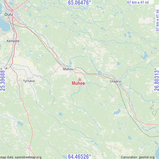
Muhos GPS coordinates[2]
64° 46' 0.012" North, 26° 6' 0" East
| Map corner | latitude | longitude |
|---|---|---|
| Upper-left | 65.06476°, | 25.39688° |
| Center: | 64.76667°, | 26.1° |
| Lower-right: | 64.46526°, | 26.80313° |
| Map W x H: | 66.7×66.7 km | = 41.4×41.4mi |
| max Lat: | 69.90864° ⇑9.2% North |
| Muhos: | 64.76667° |
| min Lat: | ⇓90.8% South 59.83333° |
| min Long | Muhos | max Long |
| 21.2° | 26.1° | 30.93276° |
| W 72%⇐ | ⇒28% E |
Elevation
Elevation of Muhos is 62 m = 203 ft, and this is 15.1 m = 50 ft below average elevation for this country.
| Max E: |
299 m = 981 ft | 60% |
| Avg. | 77.1 m = 253 ft | |
| Muhos | 62 m = 203 ft | |
Min E: |
1 m = 3 ft | 40% |
See also: Finland elevation on elevation.city.
Geographical zone
Muhos is located in North temperate zone (between Tropic of Cancer and the Arctic Circle). Distance of this North polar circle is 199.8 km =124.1 mi to North.| Distance of | km | miles | from Muhos |
|---|---|---|---|
| North Pole | 2805.7 | 1743.4 | to North |
| Arctic Circle | 199.8 | 124.1 | to North |
| Tropic Cancer | 4595.5 | 2855.5 | to South |
| Equator | 7201.4 | 4474.7 | to South |


Nearby cities:
15 places around Muhos: (largest is in red/bold)
• Kempele
32.6 km =20.3 mi,  300°
300°
• Kestilä
47.1 km =29.3 mi,  169°
169°
• Kiiminki
43 km =26.7 mi,  340°
340°
• Liminka
32.8 km =20.4 mi,  278°
278°
• Lumijoki
44 km =27.3 mi, 280°
• Muhos
6.8 km =4.2 mi,  312°
312°
• Oulu
40.4 km =25.1 mi, 312°
• Oulunsalo
37.5 km =23.3 mi, 299°
• Pulkkila
56.7 km =35.2 mi,  191°
191°
• Rantsila
35.6 km =22.1 mi,  215°
215°
• Ruukki
48.8 km =30.3 mi,  256°
256°
• Tyrnävä
21.2 km =13.2 mi,  269°
269°
• Utajärvi
13.6 km =8.5 mi,  97°
97°
• Vaala
41.4 km =25.7 mi,  122°
122°
• Ylikiiminki
35.9 km =22.3 mi,  11°
11°
Sources, notices
• [Note1] Compared only with cities in Finland existing in our database
• [Src1] Map data: © OpenStreetMap contributors (CC-BY-SA)
• [Src2] Other city data from geonames.org with taken over terms of usage.
• [Src3] Geographical zone / Annual Mean Temperature by Robert A. Rohde @ Wikipedia
