Lapua geodata
Lapua (Southern Ostrobothnia) is a seat of a third-order administrative division; located in Finland in Europe/Helsinki (GMT+3) time zone. With population of 14,091 people, there are 80 cities with bigger population in this country. Compared to other cities in Finland, 70.1% of cities are located further ↓South; 75.6% of cities are located further →East and 70.9% of cities have higher elevation than Lapua. Note1


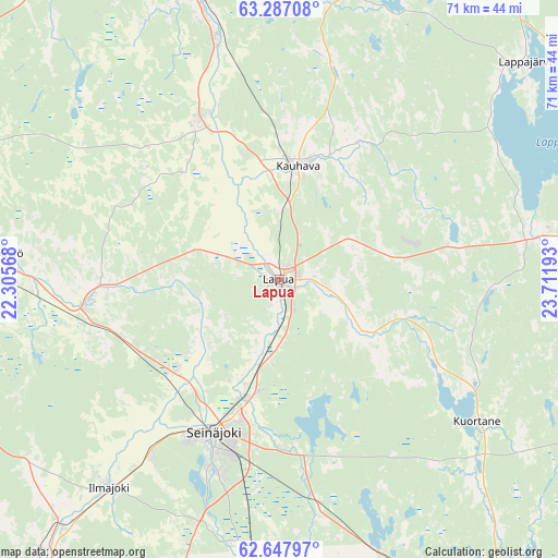
Lapua GPS coordinates[2]
62° 58' 9.372" North, 23° 0' 31.68" East
| Map corner | latitude | longitude |
|---|---|---|
| Upper-left | 63.28708°, | 22.30568° |
| Center: | 62.96927°, | 23.0088° |
| Lower-right: | 62.64797°, | 23.71193° |
| Map W x H: | 71.1×71.1 km | = 44.2×44.2mi |
| max Lat: | 69.90864° ⇑29.9% North |
| Lapua: | 62.96927° |
| min Lat: | ⇓70.1% South 59.83333° |
| min Long | Lapua | max Long |
| 21.2° | 23.0088° | 30.93276° |
| W 24.4%⇐ | ⇒75.6% E |
Elevation
Elevation of Lapua is 39 m = 128 ft, and this is 38.1 m = 125 ft below average elevation for this country.
| Max E: |
299 m = 981 ft | 70.9% |
| Avg. | 77.1 m = 253 ft | |
| Lapua | 39 m = 128 ft | |
Min E: |
1 m = 3 ft | 29.1% |
See also: Finland elevation on elevation.city.
Geographical zone
Lapua is located in North temperate zone (between Tropic of Cancer and the Arctic Circle). Distance of this North polar circle is 399.6 km =248.3 mi to North.| Distance of | km | miles | from Lapua |
|---|---|---|---|
| North Pole | 3005.5 | 1867.5 | to North |
| Arctic Circle | 399.6 | 248.3 | to North |
| Tropic Cancer | 4395.6 | 2731.3 | to South |
| Equator | 7001.5 | 4350.5 | to South |


Nearby cities:
15 places around Lapua: (largest is in red/bold)
• Alahärmä
30.4 km =18.9 mi,  344°
344°
• Alajärvi
40.9 km =25.4 mi,  85°
85°
• Ilmajoki
34.5 km =21.4 mi,  220°
220°
• Isokyrö
34.4 km =21.4 mi,  277°
277°
• Kauhava
15.2 km =9.4 mi,  11°
11°
• Kortesjärvi
37.6 km =23.4 mi, 12°
• Kuortane
31.2 km =19.4 mi,  127°
127°
• Lappajärvi
40.6 km =25.2 mi,  50°
50°
• Nurmo
16.4 km =10.2 mi,  197°
197°
• Seinäjoki
21.5 km =13.4 mi,  205°
205°
• Vimpeli
46.1 km =28.6 mi,  62°
62°
• Vörå
42.4 km =26.3 mi,  295°
295°
• Ylihärmä
23.1 km =14.4 mi,  330°
330°
• Ylistaro
25.3 km =15.7 mi,  262°
262°
• Älajärvi
40.9 km =25.4 mi, 85°
Sources, notices
• [Note1] Compared only with cities in Finland existing in our database
• [Src1] Map data: © OpenStreetMap contributors (CC-BY-SA)
• [Src2] Other city data from geonames.org with taken over terms of usage.
• [Src3] Geographical zone / Annual Mean Temperature by Robert A. Rohde @ Wikipedia
