Lappajärvi geodata
Lappajärvi (Southern Ostrobothnia) is a seat of a third-order administrative division; located in Finland in Europe/Helsinki (GMT+3) time zone. With population of 3,588 people, there are 263 cities with bigger population in this country. Compared to other cities in Finland, 75.2% of cities are located further ↓South; 67.1% of cities are located further →East and 54.7% of cities have higher elevation than Lappajärvi. Note1


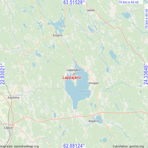
Lappajärvi GPS coordinates[2]
63° 12' 0" North, 23° 37' 59.988" East
| Map corner | latitude | longitude |
|---|---|---|
| Upper-left | 63.51529°, | 22.93021° |
| Center: | 63.2°, | 23.63333° |
| Lower-right: | 62.88124°, | 24.33646° |
| Map W x H: | 70.5×70.5 km | = 43.8×43.8mi |
| max Lat: | 69.90864° ⇑24.8% North |
| Lappajärvi: | 63.2° |
| min Lat: | ⇓75.2% South 59.83333° |
| min Long | Lappajärvi | max Long |
| 21.2° | 23.63333° | 30.93276° |
| W 32.9%⇐ | ⇒67.1% E |
Elevation
Elevation of Lappajärvi is 74 m = 243 ft, and this is 3.1 m = 10 ft below average elevation for this country.
| Max E: |
299 m = 981 ft | 54.7% |
| Avg. | 77.1 m = 253 ft | |
| Lappajärvi | 74 m = 243 ft | |
Min E: |
1 m = 3 ft | 45.3% |
See also: Finland elevation on elevation.city.
Geographical zone
Lappajärvi is located in North temperate zone (between Tropic of Cancer and the Arctic Circle). Distance of this North polar circle is 374 km =232.4 mi to North.| Distance of | km | miles | from Lappajärvi |
|---|---|---|---|
| North Pole | 2979.9 | 1851.6 | to North |
| Arctic Circle | 374 | 232.4 | to North |
| Tropic Cancer | 4421.3 | 2747.3 | to South |
| Equator | 7027.2 | 4366.5 | to South |


Nearby cities:
15 places around Lappajärvi: (largest is in red/bold)
• Alahärmä
39.4 km =24.5 mi,  275°
275°
• Alajärvi
24.1 km =15 mi,  157°
157°
• Evijärvi
20 km =12.4 mi,  337°
337°
• Halsua
39.8 km =24.7 mi,  41°
41°
• Kauhava
30.2 km =18.8 mi,  249°
249°
• Kaustinen
38.9 km =24.2 mi,  4°
4°
• Kortesjärvi
25.9 km =16.1 mi,  295°
295°
• Kuortane
45 km =28 mi,  188°
188°
• Lapua
40.6 km =25.2 mi,  230°
230°
• Perho
39.3 km =24.4 mi,  87°
87°
• Soini
47.3 km =29.4 mi,  141°
141°
• Veteli
31.8 km =19.8 mi,  13°
13°
• Vimpeli
10.2 km =6.3 mi,  114°
114°
• Ylihärmä
43 km =26.7 mi,  262°
262°
• Älajärvi
24 km =14.9 mi, 157°
Sources, notices
• [Note1] Compared only with cities in Finland existing in our database
• [Src1] Map data: © OpenStreetMap contributors (CC-BY-SA)
• [Src2] Other city data from geonames.org with taken over terms of usage.
• [Src3] Geographical zone / Annual Mean Temperature by Robert A. Rohde @ Wikipedia
