Kaustinen geodata
Kaustinen (Central Ostrobothnia) is a seat of a third-order administrative division; located in Finland in Europe/Helsinki (GMT+3) time zone. With population of 4,404 people, there are 233 cities with bigger population in this country. Compared to other cities in Finland, 79.9% of cities are located further ↓South; 66% of cities are located further →East and 58.1% of cities have higher elevation than Kaustinen. Note1


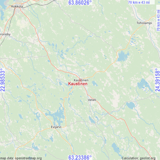
Kaustinen GPS coordinates[2]
63° 32' 55.608" North, 23° 41' 18.42" East
| Map corner | latitude | longitude |
|---|---|---|
| Upper-left | 63.86026°, | 22.98533° |
| Center: | 63.54878°, | 23.68845° |
| Lower-right: | 63.23386°, | 24.39158° |
| Map W x H: | 69.6×69.6 km | = 43.2×43.2mi |
| max Lat: | 69.90864° ⇑20.1% North |
| Kaustinen: | 63.54878° |
| min Lat: | ⇓79.9% South 59.83333° |
| min Long | Kaustinen | max Long |
| 21.2° | 23.68845° | 30.93276° |
| W 34%⇐ | ⇒66% E |
Elevation
Elevation of Kaustinen is 66 m = 217 ft, and this is 11.1 m = 36 ft below average elevation for this country.
| Max E: |
299 m = 981 ft | 58.1% |
| Avg. | 77.1 m = 253 ft | |
| Kaustinen | 66 m = 217 ft | |
Min E: |
1 m = 3 ft | 41.9% |
See also: Finland elevation on elevation.city.
Geographical zone
Kaustinen is located in North temperate zone (between Tropic of Cancer and the Arctic Circle). Distance of this North polar circle is 335.2 km =208.3 mi to North.| Distance of | km | miles | from Kaustinen |
|---|---|---|---|
| North Pole | 2941.1 | 1827.5 | to North |
| Arctic Circle | 335.2 | 208.3 | to North |
| Tropic Cancer | 4460 | 2771.3 | to South |
| Equator | 7066 | 4390.6 | to South |


Nearby cities:
15 places around Kaustinen: (largest is in red/bold)
• Bennäs
44.3 km =27.5 mi,  277°
277°
• Evijärvi
22.7 km =14.1 mi,  206°
206°
• Halsua
25.4 km =15.8 mi,  111°
111°
• Jakobstad
50.7 km =31.5 mi,  286°
286°
• Kannus
40.4 km =25.1 mi,  14°
14°
• Kokkola
42.3 km =26.3 mi,  319°
319°
• Kortesjärvi
37.9 km =23.5 mi,  223°
223°
• Kronoby
38 km =23.6 mi,  301°
301°
• Kälviä
36.6 km =22.7 mi,  341°
341°
• Lappajärvi
38.9 km =24.2 mi,  184°
184°
• Lestijärvi
47.7 km =29.6 mi,  92°
92°
• Toholampi
36.8 km =22.9 mi,  48°
48°
• Ullava
20.4 km =12.7 mi,  73°
73°
• Veteli
9.1 km =5.7 mi,  149°
149°
• Vimpeli
43.5 km =27 mi,  171°
171°
Sources, notices
• [Note1] Compared only with cities in Finland existing in our database
• [Src1] Map data: © OpenStreetMap contributors (CC-BY-SA)
• [Src2] Other city data from geonames.org with taken over terms of usage.
• [Src3] Geographical zone / Annual Mean Temperature by Robert A. Rohde @ Wikipedia
