Jyväskylä geodata
Jyväskylä (Central Finland) is a seat of a first-order administrative division; located in Finland in Europe/Helsinki (GMT+3) time zone. With population of 85,026 people, there are 8 cities with bigger population in this country. Compared to other cities in Finland, 56.8% of cities are located further ↓South; 66.9% of cities are located further ←West and 72.9% of cities have lower elevation than Jyväskylä. Note1


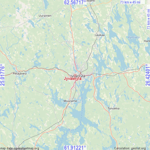
Jyväskylä GPS coordinates[2]
62° 14' 29.292" North, 25° 43' 15.168" East
| Map corner | latitude | longitude |
|---|---|---|
| Upper-left | 62.56717°, | 25.01776° |
| Center: | 62.24147°, | 25.72088° |
| Lower-right: | 61.91221°, | 26.42401° |
| Map W x H: | 72.8×72.8 km | = 45.2×45.2mi |
| max Lat: | 69.90864° ⇑43.2% North |
| Jyväskylä: | 62.24147° |
| min Lat: | ⇓56.8% South 59.83333° |
| min Long | Jyväskylä | max Long |
| 21.2° | 25.72088° | 30.93276° |
| W 66.9%⇐ | ⇒33.1% E |
Elevation
Elevation of Jyväskylä is 109 m = 358 ft, and this is 31.9 m = 105 ft above average elevation for this country.
| Max E: |
299 m = 981 ft | 27.1% |
| Jyväskylä | 109 m 358 ft | |
| Avg. | 77.1 m = 253 ft | |
Min E: |
1 m = 3 ft | 72.9% |
See also: Jyväskylä elevation on elevation.city.
Geographical zone
Jyväskylä is located in North temperate zone (between Tropic of Cancer and the Arctic Circle). Distance of this North polar circle is 480.6 km =298.6 mi to North.| Distance of | km | miles | from Jyväskylä |
|---|---|---|---|
| North Pole | 3086.5 | 1917.9 | to North |
| Arctic Circle | 480.6 | 298.6 | to North |
| Tropic Cancer | 4314.7 | 2681 | to South |
| Equator | 6920.6 | 4300.3 | to South |


Nearby cities:
15 places around Jyväskylä: (largest is in red/bold)
• Hankasalmi
40 km =24.9 mi,  66°
66°
• Jämsä
50.2 km =31.2 mi,  213°
213°
• Jämsänkoski
45.9 km =28.5 mi,  218°
218°
• Korpilahti
26.5 km =16.5 mi,  199°
199°
• Laukaa
22.6 km =14 mi,  31°
31°
• Leivonmäki
42.3 km =26.3 mi,  149°
149°
• Luhanka
49.4 km =30.7 mi,  180°
180°
• Muurame
12.3 km =7.6 mi,  193°
193°
• Petäjävesi
27 km =16.8 mi,  272°
272°
• Sumiainen
49.2 km =30.6 mi,  19°
19°
• Suolahti
36.5 km =22.7 mi,  10°
10°
• Säynätsalo
11.5 km =7.1 mi,  167°
167°
• Toivakka
24.5 km =15.2 mi,  129°
129°
• Uurainen
32 km =19.9 mi,  334°
334°
• Äänekoski
39.9 km =24.8 mi,  0°
0°
Sources, notices
• [Note1] Compared only with cities in Finland existing in our database
• [Src1] Map data: © OpenStreetMap contributors (CC-BY-SA)
• [Src2] Other city data from geonames.org with taken over terms of usage.
• [Src3] Geographical zone / Annual Mean Temperature by Robert A. Rohde @ Wikipedia
