Suolahti geodata
Suolahti (Central Finland) is a populated place; located in Finland in Europe/Helsinki (GMT+3) time zone. With population of 5,399 people, there are 196 cities with bigger population in this country. Compared to other cities in Finland, 62.6% of cities are located further ↓South; 68.6% of cities are located further ←West and 84% of cities have lower elevation than Suolahti. Note1


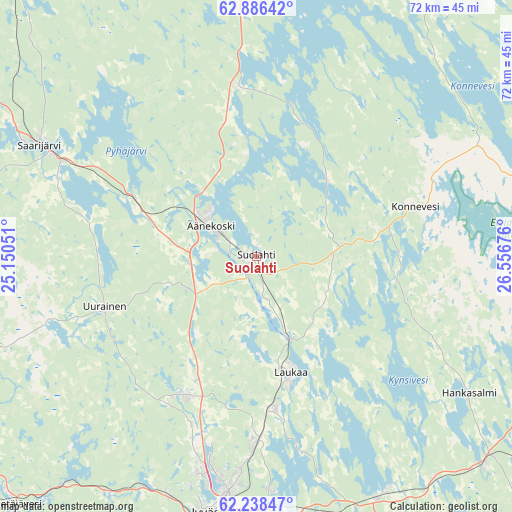
Suolahti GPS coordinates[2]
62° 33' 51.156" North, 25° 51' 13.068" East
| Map corner | latitude | longitude |
|---|---|---|
| Upper-left | 62.88642°, | 25.15051° |
| Center: | 62.56421°, | 25.85363° |
| Lower-right: | 62.23847°, | 26.55676° |
| Map W x H: | 72×72 km | = 44.7×44.7mi |
| max Lat: | 69.90864° ⇑37.4% North |
| Suolahti: | 62.56421° |
| min Lat: | ⇓62.6% South 59.83333° |
| min Long | Suolahti | max Long |
| 21.2° | 25.85363° | 30.93276° |
| W 68.6%⇐ | ⇒31.4% E |
Elevation
Elevation of Suolahti is 123 m = 404 ft, and this is 45.9 m = 151 ft above average elevation for this country.
| Max E: |
299 m = 981 ft | 16% |
| Suolahti | 123 m 404 ft | |
| Avg. | 77.1 m = 253 ft | |
Min E: |
1 m = 3 ft | 84% |
See also: Finland elevation on elevation.city.
Geographical zone
Suolahti is located in North temperate zone (between Tropic of Cancer and the Arctic Circle). Distance of this North polar circle is 444.7 km =276.3 mi to North.| Distance of | km | miles | from Suolahti |
|---|---|---|---|
| North Pole | 3050.6 | 1895.6 | to North |
| Arctic Circle | 444.7 | 276.3 | to North |
| Tropic Cancer | 4350.6 | 2703.3 | to South |
| Equator | 6956.5 | 4322.6 | to South |


Nearby cities:
15 places around Suolahti: (largest is in red/bold)
• Hankasalmi
35.9 km =22.3 mi,  124°
124°
• Jyväskylä
36.5 km =22.7 mi,  190°
190°
• Kannonkoski
54.3 km =33.7 mi,  325°
325°
• Konnevesi
24.4 km =15.2 mi,  76°
76°
• Laukaa
17.4 km =10.8 mi,  163°
163°
• Muurame
48.9 km =30.4 mi, 191°
• Petäjävesi
48.5 km =30.1 mi,  223°
223°
• Rautalampi
50.7 km =31.5 mi, 81°
• Saarijärvi
34.4 km =21.4 mi,  297°
297°
• Sumiainen
14.3 km =8.9 mi,  43°
43°
• Säynätsalo
47.3 km =29.4 mi, 185°
• Toivakka
53 km =32.9 mi,  167°
167°
• Uurainen
21.9 km =13.6 mi,  250°
250°
• Vesanto
50.1 km =31.1 mi,  34°
34°
• Äänekoski
7.3 km =4.5 mi, 302°
Sources, notices
• [Note1] Compared only with cities in Finland existing in our database
• [Src1] Map data: © OpenStreetMap contributors (CC-BY-SA)
• [Src2] Other city data from geonames.org with taken over terms of usage.
• [Src3] Geographical zone / Annual Mean Temperature by Robert A. Rohde @ Wikipedia
