Uurainen geodata
Uurainen (Central Finland) is a seat of a third-order administrative division; located in Finland in Europe/Helsinki (GMT+3) time zone. With population of 3,104 people, there are 291 cities with bigger population in this country. Compared to other cities in Finland, 61.8% of cities are located further ↓South; 63.2% of cities are located further ←West and 98.5% of cities have lower elevation than Uurainen. Note1


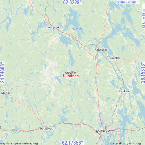
Uurainen GPS coordinates[2]
62° 30' 0" North, 25° 27' 0" East
| Map corner | latitude | longitude |
|---|---|---|
| Upper-left | 62.8229°, | 24.74688° |
| Center: | 62.5°, | 25.45° |
| Lower-right: | 62.17356°, | 26.15313° |
| Map W x H: | 72.2×72.2 km | = 44.9×44.9mi |
| max Lat: | 69.90864° ⇑38.2% North |
| Uurainen: | 62.5° |
| min Lat: | ⇓61.8% South 59.83333° |
| min Long | Uurainen | max Long |
| 21.2° | 25.45° | 30.93276° |
| W 63.2%⇐ | ⇒36.8% E |
Elevation
Elevation of Uurainen is 198 m = 650 ft, and this is 120.9 m = 397 ft above average elevation for this country.
| Max E: |
299 m = 981 ft | 1.5% |
| Uurainen | 198 m 650 ft | |
| Avg. | 77.1 m = 253 ft | |
Min E: |
1 m = 3 ft | 98.5% |
See also: Finland elevation on elevation.city.
Geographical zone
Uurainen is located in North temperate zone (between Tropic of Cancer and the Arctic Circle). Distance of this North polar circle is 451.8 km =280.7 mi to North.| Distance of | km | miles | from Uurainen |
|---|---|---|---|
| North Pole | 3057.7 | 1900 | to North |
| Arctic Circle | 451.8 | 280.7 | to North |
| Tropic Cancer | 4343.4 | 2698.9 | to South |
| Equator | 6949.3 | 4318.1 | to South |


Nearby cities:
15 places around Uurainen: (largest is in red/bold)
• Hankasalmi
52.2 km =32.4 mi,  104°
104°
• Jyväskylä
32 km =19.9 mi,  154°
154°
• Kannonkoski
52.9 km =32.9 mi,  348°
348°
• Keuruu
46.6 km =29 mi,  236°
236°
• Konnevesi
46.3 km =28.8 mi,  73°
73°
• Laukaa
27.5 km =17.1 mi,  110°
110°
• Multia
35.5 km =22.1 mi,  254°
254°
• Muurame
42.3 km =26.3 mi,  164°
164°
• Petäjävesi
30.6 km =19 mi,  204°
204°
• Pylkönmäki
38.1 km =23.7 mi,  299°
299°
• Saarijärvi
24.9 km =15.5 mi,  336°
336°
• Sumiainen
35.2 km =21.9 mi,  60°
60°
• Suolahti
21.9 km =13.6 mi, 70°
• Säynätsalo
43.3 km =26.9 mi, 157°
• Äänekoski
18.3 km =11.4 mi,  52°
52°
Sources, notices
• [Note1] Compared only with cities in Finland existing in our database
• [Src1] Map data: © OpenStreetMap contributors (CC-BY-SA)
• [Src2] Other city data from geonames.org with taken over terms of usage.
• [Src3] Geographical zone / Annual Mean Temperature by Robert A. Rohde @ Wikipedia
