Juuka geodata
Juuka (North Karelia) is a seat of a third-order administrative division; located in Finland in Europe/Helsinki (GMT+3) time zone. With population of 6,035 people, there are 176 cities with bigger population in this country. Compared to other cities in Finland, 76.1% of cities are located further ↓South; 95.3% of cities are located further ←West and 78.4% of cities have lower elevation than Juuka. Note1


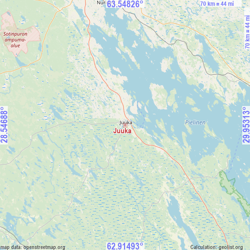
Juuka GPS coordinates[2]
63° 13' 59.988" North, 29° 15' 0" East
| Map corner | latitude | longitude |
|---|---|---|
| Upper-left | 63.54826°, | 28.54688° |
| Center: | 63.23333°, | 29.25° |
| Lower-right: | 62.91493°, | 29.95313° |
| Map W x H: | 70.4×70.4 km | = 43.7×43.7mi |
| max Lat: | 69.90864° ⇑23.9% North |
| Juuka: | 63.23333° |
| min Lat: | ⇓76.1% South 59.83333° |
| min Long | Juuka | max Long |
| 21.2° | 29.25° | 30.93276° |
| W 95.3%⇐ | ⇒4.7% E |
Elevation
Elevation of Juuka is 115 m = 377 ft, and this is 37.9 m = 124 ft above average elevation for this country.
| Max E: |
299 m = 981 ft | 21.6% |
| Juuka | 115 m 377 ft | |
| Avg. | 77.1 m = 253 ft | |
Min E: |
1 m = 3 ft | 78.4% |
See also: Finland elevation on elevation.city.
Geographical zone
Juuka is located in North temperate zone (between Tropic of Cancer and the Arctic Circle). Distance of this North polar circle is 370.3 km =230.1 mi to North.| Distance of | km | miles | from Juuka |
|---|---|---|---|
| North Pole | 2976.2 | 1849.3 | to North |
| Arctic Circle | 370.3 | 230.1 | to North |
| Tropic Cancer | 4425 | 2749.6 | to South |
| Equator | 7030.9 | 4368.8 | to South |


Nearby cities:
15 places around Juuka: (largest is in red/bold)
• Eno
65.9 km =40.9 mi,  136°
136°
• Joensuu
74.9 km =46.5 mi,  159°
159°
• Juankoski
48.8 km =30.3 mi,  247°
247°
• Kaavi
46.9 km =29.1 mi,  233°
233°
• Kontiolahti
60.6 km =37.7 mi,  150°
150°
• Lieksa
39.4 km =24.5 mi,  76°
76°
• Liperi
78.1 km =48.5 mi,  175°
175°
• Nilsiä
58.6 km =36.4 mi,  267°
267°
• Nurmes
34.8 km =21.6 mi,  350°
350°
• Outokumpu
57.5 km =35.7 mi,  191°
191°
• Polvijärvi
43 km =26.7 mi,  172°
172°
• Rautavaara
54.9 km =34.1 mi,  300°
300°
• Tuusniemi
59.8 km =37.2 mi,  219°
219°
• Valtimo
53.1 km =33 mi,  335°
335°
• Varpaisjärvi
76 km =47.2 mi,  280°
280°
Sources, notices
• [Note1] Compared only with cities in Finland existing in our database
• [Src1] Map data: © OpenStreetMap contributors (CC-BY-SA)
• [Src2] Other city data from geonames.org with taken over terms of usage.
• [Src3] Geographical zone / Annual Mean Temperature by Robert A. Rohde @ Wikipedia
