Liperi geodata
Liperi (North Karelia) is a seat of a third-order administrative division; located in Finland in Europe/Helsinki (GMT+3) time zone. With population of 11,386 people, there are 93 cities with bigger population in this country. Compared to other cities in Finland, 62.2% of cities are located further ↓South; 95.9% of cities are located further ←West and 50.6% of cities have higher elevation than Liperi. Note1


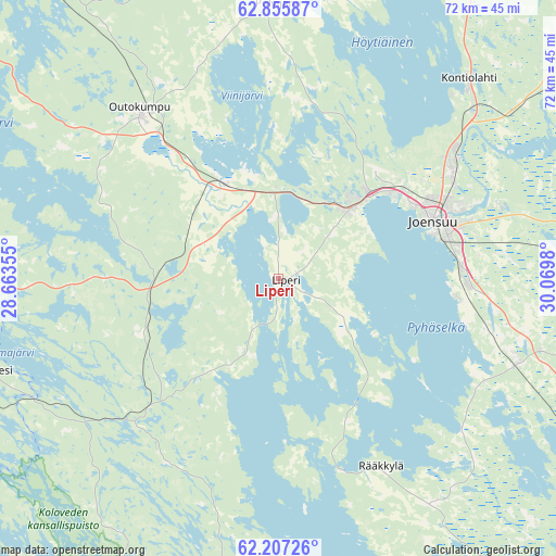
Liperi GPS coordinates[2]
62° 31' 59.988" North, 29° 22' 0.012" East
| Map corner | latitude | longitude |
|---|---|---|
| Upper-left | 62.85587°, | 28.66355° |
| Center: | 62.53333°, | 29.36667° |
| Lower-right: | 62.20726°, | 30.0698° |
| Map W x H: | 72.1×72.1 km | = 44.8×44.8mi |
| max Lat: | 69.90864° ⇑37.8% North |
| Liperi: | 62.53333° |
| min Lat: | ⇓62.2% South 59.83333° |
| min Long | Liperi | max Long |
| 21.2° | 29.36667° | 30.93276° |
| W 95.9%⇐ | ⇒4.1% E |
Elevation
Elevation of Liperi is 80 m = 262 ft, and this is 2.9 m = 10 ft above average elevation for this country.
| Max E: |
299 m = 981 ft | 50.6% |
| Liperi | 80 m 262 ft | |
| Avg. | 77.1 m = 253 ft | |
Min E: |
1 m = 3 ft | 49.4% |
See also: Finland elevation on elevation.city.
Geographical zone
Liperi is located in North temperate zone (between Tropic of Cancer and the Arctic Circle). Distance of this North polar circle is 448.1 km =278.4 mi to North.| Distance of | km | miles | from Liperi |
|---|---|---|---|
| North Pole | 3054 | 1897.7 | to North |
| Arctic Circle | 448.1 | 278.4 | to North |
| Tropic Cancer | 4347.1 | 2701.2 | to South |
| Equator | 6953.1 | 4320.5 | to South |


Nearby cities:
15 places around Liperi: (largest is in red/bold)
• Eno
50.3 km =31.3 mi,  53°
53°
• Enonkoski
54.8 km =34.1 mi,  204°
204°
• Heinävesi
40.9 km =25.4 mi,  254°
254°
• Joensuu
21.7 km =13.5 mi,  69°
69°
• Kangaslampi
63.1 km =39.2 mi, 245°
• Kiihtelysvaara
45.6 km =28.3 mi,  95°
95°
• Kitee
62.9 km =39.1 mi,  139°
139°
• Kontiolahti
35.2 km =21.9 mi,  44°
44°
• Outokumpu
28 km =17.4 mi,  320°
320°
• Polvijärvi
35.2 km =21.9 mi,  0°
0°
• Pyhäselkä
32.8 km =20.4 mi,  109°
109°
• Rääkkylä
27.3 km =17 mi,  151°
151°
• Savonranta
39.9 km =24.8 mi,  192°
192°
• Tuupovaara
64.9 km =40.3 mi,  94°
94°
• Tuusniemi
54.3 km =33.7 mi,  305°
305°
Sources, notices
• [Note1] Compared only with cities in Finland existing in our database
• [Src1] Map data: © OpenStreetMap contributors (CC-BY-SA)
• [Src2] Other city data from geonames.org with taken over terms of usage.
• [Src3] Geographical zone / Annual Mean Temperature by Robert A. Rohde @ Wikipedia
