Kontiolahti geodata
Kontiolahti (North Karelia) is a seat of a third-order administrative division; located in Finland in Europe/Helsinki (GMT+3) time zone. With population of 12,411 people, there are 85 cities with bigger population in this country. Compared to other cities in Finland, 66% of cities are located further ↓South; 98.1% of cities are located further ←West and 88.7% of cities have lower elevation than Kontiolahti. Note1


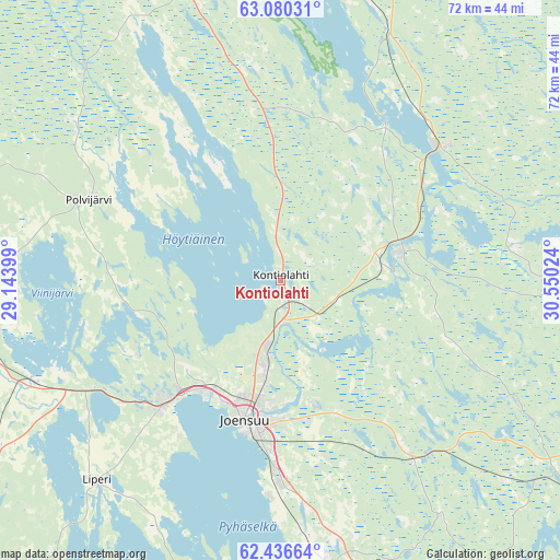
Kontiolahti GPS coordinates[2]
62° 45' 36.828" North, 29° 50' 49.596" East
| Map corner | latitude | longitude |
|---|---|---|
| Upper-left | 63.08031°, | 29.14399° |
| Center: | 62.76023°, | 29.84711° |
| Lower-right: | 62.43664°, | 30.55024° |
| Map W x H: | 71.6×71.6 km | = 44.5×44.5mi |
| max Lat: | 69.90864° ⇑34% North |
| Kontiolahti: | 62.76023° |
| min Lat: | ⇓66% South 59.83333° |
| min Long | Kontiolahti | max Long |
| 21.2° | 29.84711° | 30.93276° |
| W 98.1%⇐ | ⇒1.9% E |
Elevation
Elevation of Kontiolahti is 138 m = 453 ft, and this is 60.9 m = 200 ft above average elevation for this country.
| Max E: |
299 m = 981 ft | 11.3% |
| Kontiolahti | 138 m 453 ft | |
| Avg. | 77.1 m = 253 ft | |
Min E: |
1 m = 3 ft | 88.7% |
See also: Finland elevation on elevation.city.
Geographical zone
Kontiolahti is located in North temperate zone (between Tropic of Cancer and the Arctic Circle). Distance of this North polar circle is 422.9 km =262.8 mi to North.| Distance of | km | miles | from Kontiolahti |
|---|---|---|---|
| North Pole | 3028.8 | 1882 | to North |
| Arctic Circle | 422.9 | 262.8 | to North |
| Tropic Cancer | 4372.4 | 2716.9 | to South |
| Equator | 6978.3 | 4336.1 | to South |


Nearby cities:
15 places around Kontiolahti: (largest is in red/bold)
• Eno
16.4 km =10.2 mi,  72°
72°
• Ilomantsi
56.2 km =34.9 mi,  100°
100°
• Joensuu
18.2 km =11.3 mi,  193°
193°
• Juuka
60.6 km =37.7 mi,  330°
330°
• Kiihtelysvaara
36 km =22.4 mi,  144°
144°
• Lieksa
62.5 km =38.8 mi,  7°
7°
• Liperi
35.2 km =21.9 mi,  224°
224°
• Outokumpu
42.5 km =26.4 mi,  264°
264°
• Polvijärvi
26.4 km =16.4 mi,  292°
292°
• Pyhäselkä
36.9 km =22.9 mi,  170°
170°
• Rääkkylä
50.7 km =31.5 mi, 193°
• Savonranta
72.3 km =44.9 mi,  207°
207°
• Tohmajärvi
69.8 km =43.4 mi,  156°
156°
• Tuupovaara
50.4 km =31.3 mi,  127°
127°
• Tuusniemi
68.8 km =42.8 mi,  275°
275°
Sources, notices
• [Note1] Compared only with cities in Finland existing in our database
• [Src1] Map data: © OpenStreetMap contributors (CC-BY-SA)
• [Src2] Other city data from geonames.org with taken over terms of usage.
• [Src3] Geographical zone / Annual Mean Temperature by Robert A. Rohde @ Wikipedia
