Isojoki geodata
Isojoki (Southern Ostrobothnia) is a seat of a third-order administrative division; located in Finland in Europe/Helsinki (GMT+3) time zone. With population of 2,585 people, there are 320 cities with bigger population in this country. Compared to other cities in Finland, 54.7% of cities are located further ↓South; 91.5% of cities are located further →East and 77.4% of cities have lower elevation than Isojoki. Note1


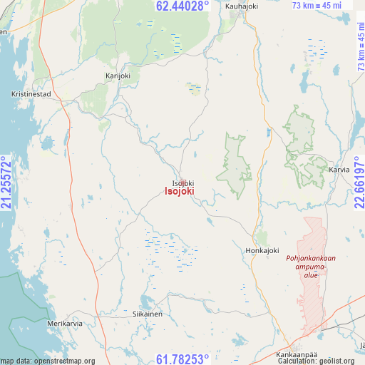
Isojoki GPS coordinates[2]
62° 6' 47.484" North, 21° 57' 31.824" East
| Map corner | latitude | longitude |
|---|---|---|
| Upper-left | 62.44028°, | 21.25572° |
| Center: | 62.11319°, | 21.95884° |
| Lower-right: | 61.78253°, | 22.66197° |
| Map W x H: | 73.1×73.1 km | = 45.4×45.4mi |
| max Lat: | 69.90864° ⇑45.3% North |
| Isojoki: | 62.11319° |
| min Lat: | ⇓54.7% South 59.83333° |
| min Long | Isojoki | max Long |
| 21.2° | 21.95884° | 30.93276° |
| W 8.5%⇐ | ⇒91.5% E |
Elevation
Elevation of Isojoki is 114 m = 374 ft, and this is 36.9 m = 121 ft above average elevation for this country.
| Max E: |
299 m = 981 ft | 22.6% |
| Isojoki | 114 m 374 ft | |
| Avg. | 77.1 m = 253 ft | |
Min E: |
1 m = 3 ft | 77.4% |
See also: Finland elevation on elevation.city.
Geographical zone
Isojoki is located in North temperate zone (between Tropic of Cancer and the Arctic Circle). Distance of this North polar circle is 494.8 km =307.5 mi to North.| Distance of | km | miles | from Isojoki |
|---|---|---|---|
| North Pole | 3100.7 | 1926.7 | to North |
| Arctic Circle | 494.8 | 307.5 | to North |
| Tropic Cancer | 4300.4 | 2672.1 | to South |
| Equator | 6906.3 | 4291.4 | to South |


Nearby cities:
15 places around Isojoki: (largest is in red/bold)
• Honkajoki
21.6 km =13.4 mi,  131°
131°
• Jämijärvi
50.9 km =31.6 mi, 130°
• Kankaanpää
42.3 km =26.3 mi,  145°
145°
• Karijoki
25.3 km =15.7 mi,  329°
329°
• Karvia
31.7 km =19.7 mi,  85°
85°
• Karvia
37.2 km =23.1 mi,  74°
74°
• Kaskinen
48.6 km =30.2 mi,  308°
308°
• Kauhajoki
37.4 km =23.2 mi,  18°
18°
• Kristinestad
35.1 km =21.8 mi,  300°
300°
• Längelmäki
52 km =32.3 mi,  171°
171°
• Merikarvia
37.1 km =23.1 mi,  220°
220°
• Närpes
51.3 km =31.9 mi,  321°
321°
• Pomarkku
46.7 km =29 mi,  176°
176°
• Siikainen
27.2 km =16.9 mi,  195°
195°
• Teuva
42.5 km =26.4 mi,  344°
344°
Sources, notices
• [Note1] Compared only with cities in Finland existing in our database
• [Src1] Map data: © OpenStreetMap contributors (CC-BY-SA)
• [Src2] Other city data from geonames.org with taken over terms of usage.
• [Src3] Geographical zone / Annual Mean Temperature by Robert A. Rohde @ Wikipedia
