Längelmäki geodata
Längelmäki (Satakunta) is a populated place; located in Finland in Europe/Helsinki (GMT+3) time zone. With population of 1,636 people, there are 381 cities with bigger population in this country. Compared to other cities in Finland, 53.2% of cities are located further ↑North; 89.1% of cities are located further →East and 63.9% of cities have higher elevation than Längelmäki. Note1


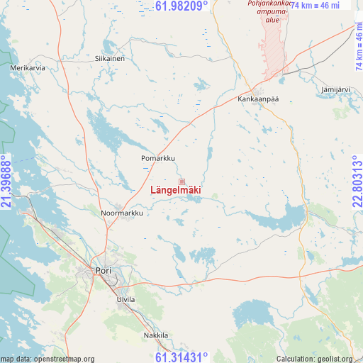
Längelmäki GPS coordinates[2]
61° 39' 0" North, 22° 6' 0" East
| Map corner | latitude | longitude |
|---|---|---|
| Upper-left | 61.98209°, | 21.39688° |
| Center: | 61.65°, | 22.1° |
| Lower-right: | 61.31431°, | 22.80313° |
| Map W x H: | 74.3×74.2 km | = 46.2×46.1mi |
| max Lat: | 69.90864° ⇑53.2% North |
| Längelmäki: | 61.65° |
| min Lat: | ⇓46.8% South 59.83333° |
| min Long | Längelmäki | max Long |
| 21.2° | 22.1° | 30.93276° |
| W 10.9%⇐ | ⇒89.1% E |
Elevation
Elevation of Längelmäki is 52 m = 171 ft, and this is 25.1 m = 82 ft below average elevation for this country.
| Max E: |
299 m = 981 ft | 63.9% |
| Avg. | 77.1 m = 253 ft | |
| Längelmäki | 52 m = 171 ft | |
Min E: |
1 m = 3 ft | 36.1% |
See also: Finland elevation on elevation.city.
Geographical zone
Längelmäki is located in North temperate zone (between Tropic of Cancer and the Arctic Circle). Distance of this North polar circle is 546.3 km =339.5 mi to North.| Distance of | km | miles | from Längelmäki |
|---|---|---|---|
| North Pole | 3152.2 | 1958.7 | to North |
| Arctic Circle | 546.3 | 339.5 | to North |
| Tropic Cancer | 4248.9 | 2640.1 | to South |
| Equator | 6854.8 | 4259.4 | to South |


Nearby cities:
15 places around Längelmäki: (largest is in red/bold)
• Harjavalta
37.1 km =23.1 mi,  177°
177°
• Honkajoki
38.1 km =23.7 mi,  13°
13°
• Jämijärvi
36.6 km =22.7 mi,  59°
59°
• Kankaanpää
23.6 km =14.7 mi,  45°
45°
• Kiikoinen
33.4 km =20.8 mi,  130°
130°
• Kullaa
20.3 km =12.6 mi,  170°
170°
• Lavia
27 km =16.8 mi,  101°
101°
• Merikarvia
39.1 km =24.3 mi,  306°
306°
• Nakkila
31.9 km =19.8 mi,  189°
189°
• Noormarkku
13.8 km =8.6 mi,  242°
242°
• Pomarkku
6.8 km =4.2 mi,  315°
315°
• Pori
25 km =15.5 mi,  222°
222°
• Siikainen
29.2 km =18.1 mi,  329°
329°
• Suodenniemi
37.6 km =23.4 mi,  105°
105°
• Ulvila
27.5 km =17.1 mi,  206°
206°
Sources, notices
• [Note1] Compared only with cities in Finland existing in our database
• [Src1] Map data: © OpenStreetMap contributors (CC-BY-SA)
• [Src2] Other city data from geonames.org with taken over terms of usage.
• [Src3] Geographical zone / Annual Mean Temperature by Robert A. Rohde @ Wikipedia
