Wolxheim geodata
Wolxheim (Grand Est) is a populated place; located in France in Europe/Paris (GMT+2) time zone. With population of 822 people, there are 10372 cities with bigger population in this country. Compared to other cities in France, 70.1% of cities are located further ↓South; 98.1% of cities are located further ←West and 60.5% of cities have lower elevation than Wolxheim. Note1
Administrative division(s):
- Level 1: Grand Est
- Level 2: Bas-Rhin
- Level 3: Arrondissement de Molsheim
- Level 4: Wolxheim


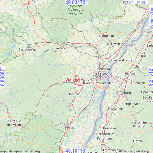
Wolxheim GPS coordinates[2]
48° 34' 6.96" North, 7° 30' 43.164" East
| Map corner | latitude | longitude |
|---|---|---|
| Upper-left | 49.03173°, | 6.80887° |
| Center: | 48.5686°, | 7.51199° |
| Lower-right: | 48.10118°, | 8.21512° |
| Map W x H: | 103.5×103.5 km | = 64.3×64.3mi |
| max Lat: | 51.07786° ⇑29.9% North |
| Wolxheim: | 48.5686° |
| min Lat: | ⇓70.1% South 41.3874° |
| min Long | Wolxheim | max Long |
| -5.08615° | 7.51199° | 9.52242° |
| W 98.1%⇐ | ⇒1.9% E |
Elevation
Elevation of Wolxheim is 172 m = 564 ft, and this is 21.7 m = 71 ft below average elevation for this country.
| Max E: |
2333 m = 7654 ft | 39.5% |
| Avg. | 193.7 m = 635 ft | |
| Wolxheim | 172 m = 564 ft | |
Min E: |
-1 m = -3 ft | 60.5% |
See also: France elevation on elevation.city.
Geographical zone
Wolxheim is located in North temperate zone (between Tropic of Cancer and the Arctic Circle). Distance of this North polar circle is 2000.9 km =1243.3 mi to North.| Distance of | km | miles | from Wolxheim |
|---|---|---|---|
| North Pole | 4606.7 | 2862.5 | to North |
| Arctic Circle | 2000.9 | 1243.3 | to North |
| Tropic Cancer | 2794.4 | 1736.4 | to South |
| Equator | 5400.3 | 3355.6 | to South |


Nearby cities:
15 places around Wolxheim: (largest is in red/bold)
• Avolsheim
1.2 km =0.7 mi,  228°
228°
• Bergbieten
4.1 km =2.5 mi,  281°
281°
• Dachstein
1.7 km =1.1 mi,  118°
118°
• Dahlenheim
2 km =1.2 mi,  349°
349°
• Dangolsheim
3.5 km =2.2 mi, 275°
• Dorlisheim
5.2 km =3.2 mi,  201°
201°
• Ergersheim
1.2 km =0.7 mi,  82°
82°
• Ernolsheim-Bruche
3.9 km =2.4 mi,  95°
95°
• Irmstett
3.3 km =2.1 mi,  311°
311°
• Kirchheim
4.7 km =2.9 mi, 345°
• Molsheim
3.5 km =2.2 mi,  205°
205°
• Mutzig
5.2 km =3.2 mi, 232°
• Osthoffen
3.8 km =2.4 mi,  57°
57°
• Soultz-les-Bains
1.9 km =1.2 mi, 280°
• Traenheim
4.5 km =2.8 mi, 311°
Sources, notices
• [Note1] Compared only with cities in France existing in our database
• [Src1] Map data: © OpenStreetMap contributors (CC-BY-SA)
• [Src2] Other city data from geonames.org with taken over terms of usage.
• [Src3] Geographical zone / Annual Mean Temperature by Robert A. Rohde @ Wikipedia
