Wingen-sur-Moder geodata
Wingen-sur-Moder (Grand Est) is a populated place; located in France in Europe/Paris (GMT+2) time zone. With population of 1,563 people, there are 5958 cities with bigger population in this country. Compared to other cities in France, 78% of cities are located further ↓South; 97.1% of cities are located further ←West and 69.6% of cities have lower elevation than Wingen-sur-Moder. Note1
Administrative division(s):
- Level 1: Grand Est
- Level 2: Bas-Rhin
- Level 3: Arrondissement de Saverne
- Level 4: Wingen-sur-Moder


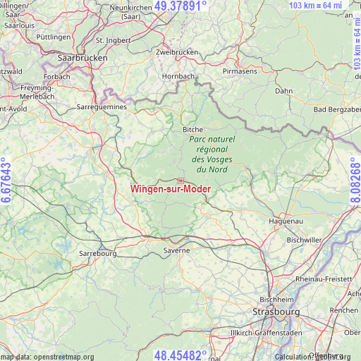
Wingen-sur-Moder GPS coordinates[2]
48° 55' 8.4" North, 7° 22' 46.38" East
| Map corner | latitude | longitude |
|---|---|---|
| Upper-left | 49.37891°, | 6.67643° |
| Center: | 48.919°, | 7.37955° |
| Lower-right: | 48.45482°, | 8.08268° |
| Map W x H: | 102.7×102.7 km | = 63.8×63.8mi |
| max Lat: | 51.07786° ⇑22% North |
| Wingen-sur-Moder: | 48.919° |
| min Lat: | ⇓78% South 41.3874° |
| min Long | Wingen-sur-Mode | max Long |
| -5.08615° | 7.37955° | 9.52242° |
| W 97.1%⇐ | ⇒2.9% E |
Elevation
Elevation of Wingen-sur-Moder is 217 m = 712 ft, and this is 23.3 m = 76 ft above average elevation for this country.
| Max E: |
2333 m = 7654 ft | 30.4% |
| Wingen-sur-Moder | 217 m 712 ft | |
| Avg. | 193.7 m = 635 ft | |
Min E: |
-1 m = -3 ft | 69.6% |
See also: France elevation on elevation.city.
Geographical zone
Wingen-sur-Moder is located in North temperate zone (between Tropic of Cancer and the Arctic Circle). Distance of this North polar circle is 1961.9 km =1219.1 mi to North.| Distance of | km | miles | from Wingen-sur-Moder |
|---|---|---|---|
| North Pole | 4567.8 | 2838.3 | to North |
| Arctic Circle | 1961.9 | 1219.1 | to North |
| Tropic Cancer | 2833.4 | 1760.6 | to South |
| Equator | 5439.3 | 3379.8 | to South |


Nearby cities:
15 places around Wingen-sur-Moder: (largest is in red/bold)
• Goetzenbruck
6.5 km =4 mi,  0°
0°
• Ingwiller
8.9 km =5.5 mi,  125°
125°
• La Petite-Pierre
7.9 km =4.9 mi,  212°
212°
• Lemberg
9.2 km =5.7 mi,  359°
359°
• Lichtenberg
7.5 km =4.7 mi,  87°
87°
• Meisenthal
5.9 km =3.7 mi,  340°
340°
• Montbronn
9.6 km =6 mi,  328°
328°
• Reipertswiller
6.4 km =4 mi,  75°
75°
• Rosteig
3.4 km =2.1 mi,  296°
296°
• Saint-Louis-lès-Bitche
8 km =5 mi,  345°
345°
• Soucht
5.5 km =3.4 mi,  323°
323°
• Weinbourg
7 km =4.3 mi,  139°
139°
• Weislingen
9.2 km =5.7 mi,  271°
271°
• Weiterswiller
7.6 km =4.7 mi,  161°
161°
• Wimmenau
3.2 km =2 mi,  103°
103°
Sources, notices
• [Note1] Compared only with cities in France existing in our database
• [Src1] Map data: © OpenStreetMap contributors (CC-BY-SA)
• [Src2] Other city data from geonames.org with taken over terms of usage.
• [Src3] Geographical zone / Annual Mean Temperature by Robert A. Rohde @ Wikipedia
