Weiterswiller geodata
Weiterswiller (Grand Est) is a populated place; located in France in Europe/Paris (GMT+2) time zone. With population of 582 people, there are 13612 cities with bigger population in this country. Compared to other cities in France, 76.7% of cities are located further ↓South; 97.4% of cities are located further ←West and 69.2% of cities have lower elevation than Weiterswiller. Note1
Administrative division(s):
- Level 1: Grand Est
- Level 2: Bas-Rhin
- Level 3: Arrondissement de Saverne
- Level 4: Weiterswiller


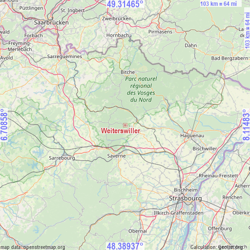
Weiterswiller GPS coordinates[2]
48° 51' 14.94" North, 7° 24' 42.156" East
| Map corner | latitude | longitude |
|---|---|---|
| Upper-left | 49.31465°, | 6.70858° |
| Center: | 48.85415°, | 7.41171° |
| Lower-right: | 48.38937°, | 8.11483° |
| Map W x H: | 102.9×102.9 km | = 63.9×63.9mi |
| max Lat: | 51.07786° ⇑23.3% North |
| Weiterswiller: | 48.85415° |
| min Lat: | ⇓76.7% South 41.3874° |
| min Long | Weiterswiller | max Long |
| -5.08615° | 7.41171° | 9.52242° |
| W 97.4%⇐ | ⇒2.6% E |
Elevation
Elevation of Weiterswiller is 215 m = 705 ft, and this is 21.3 m = 70 ft above average elevation for this country.
| Max E: |
2333 m = 7654 ft | 30.8% |
| Weiterswiller | 215 m 705 ft | |
| Avg. | 193.7 m = 635 ft | |
Min E: |
-1 m = -3 ft | 69.2% |
See also: France elevation on elevation.city.
Geographical zone
Weiterswiller is located in North temperate zone (between Tropic of Cancer and the Arctic Circle). Distance of this North polar circle is 1969.1 km =1223.5 mi to North.| Distance of | km | miles | from Weiterswiller |
|---|---|---|---|
| North Pole | 4575 | 2842.8 | to North |
| Arctic Circle | 1969.1 | 1223.5 | to North |
| Tropic Cancer | 2826.2 | 1756.1 | to South |
| Equator | 5432.1 | 3375.3 | to South |


Nearby cities:
15 places around Weiterswiller: (largest is in red/bold)
• Bosselshausen
9 km =5.6 mi,  127°
127°
• Bouxwiller
6 km =3.7 mi,  122°
122°
• Dossenheim-sur-Zinsel
5.4 km =3.4 mi,  186°
186°
• Ernolsheim-lès-Saverne
7.3 km =4.5 mi,  197°
197°
• Hattmatt
7.1 km =4.4 mi,  174°
174°
• Ingwiller
5.4 km =3.4 mi,  67°
67°
• La Petite-Pierre
6.6 km =4.1 mi,  274°
274°
• Lichtenberg
9.1 km =5.7 mi,  34°
34°
• Menchhoffen
6.2 km =3.9 mi,  84°
84°
• Neuwiller-lès-Saverne
3.3 km =2.1 mi, 188°
• Obermodern-Zutzendorf
8.9 km =5.5 mi,  92°
92°
• Steinbourg
9.3 km =5.8 mi,  179°
179°
• Weinbourg
2.9 km =1.8 mi,  48°
48°
• Wimmenau
6.5 km =4 mi,  6°
6°
• Wingen-sur-Moder
7.6 km =4.7 mi,  341°
341°
Sources, notices
• [Note1] Compared only with cities in France existing in our database
• [Src1] Map data: © OpenStreetMap contributors (CC-BY-SA)
• [Src2] Other city data from geonames.org with taken over terms of usage.
• [Src3] Geographical zone / Annual Mean Temperature by Robert A. Rohde @ Wikipedia
