Rosteig geodata
Rosteig (Grand Est) is a populated place; located in France in Europe/Paris (GMT+2) time zone. With population of 606 people, there are 13224 cities with bigger population in this country. Compared to other cities in France, 78.2% of cities are located further ↓South; 96.8% of cities are located further ←West and 75.9% of cities have lower elevation than Rosteig. Note1
Administrative division(s):
- Level 1: Grand Est
- Level 2: Bas-Rhin
- Level 3: Arrondissement de Saverne
- Level 4: Rosteig


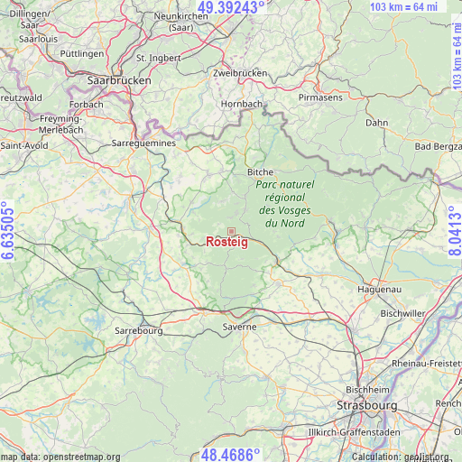
Rosteig GPS coordinates[2]
48° 55' 57.54" North, 7° 20' 17.448" East
| Map corner | latitude | longitude |
|---|---|---|
| Upper-left | 49.39243°, | 6.63505° |
| Center: | 48.93265°, | 7.33818° |
| Lower-right: | 48.4686°, | 8.0413° |
| Map W x H: | 102.7×102.7 km | = 63.8×63.8mi |
| max Lat: | 51.07786° ⇑21.8% North |
| Rosteig: | 48.93265° |
| min Lat: | ⇓78.2% South 41.3874° |
| min Long | Rosteig | max Long |
| -5.08615° | 7.33818° | 9.52242° |
| W 96.8%⇐ | ⇒3.2% E |
Elevation
Elevation of Rosteig is 256 m = 840 ft, and this is 62.3 m = 204 ft above average elevation for this country.
| Max E: |
2333 m = 7654 ft | 24.1% |
| Rosteig | 256 m 840 ft | |
| Avg. | 193.7 m = 635 ft | |
Min E: |
-1 m = -3 ft | 75.9% |
See also: France elevation on elevation.city.
Geographical zone
Rosteig is located in North temperate zone (between Tropic of Cancer and the Arctic Circle). Distance of this North polar circle is 1960.4 km =1218.1 mi to North.| Distance of | km | miles | from Rosteig |
|---|---|---|---|
| North Pole | 4566.3 | 2837.4 | to North |
| Arctic Circle | 1960.4 | 1218.1 | to North |
| Tropic Cancer | 2834.9 | 1761.5 | to South |
| Equator | 5440.8 | 3380.8 | to South |


Nearby cities:
15 places around Rosteig: (largest is in red/bold)
• Butten
9.4 km =5.8 mi,  296°
296°
• Enchenberg
9 km =5.6 mi,  0°
0°
• Goetzenbruck
5.9 km =3.7 mi,  31°
31°
• La Petite-Pierre
8.3 km =5.2 mi,  188°
188°
• Lemberg
8.3 km =5.2 mi,  21°
21°
• Meisenthal
4.2 km =2.6 mi,  14°
14°
• Montbronn
6.9 km =4.3 mi,  343°
343°
• Petersbach
8.6 km =5.3 mi,  217°
217°
• Reipertswiller
9.2 km =5.7 mi,  89°
89°
• Saint-Louis-lès-Bitche
6.3 km =3.9 mi, 9°
• Soucht
2.9 km =1.8 mi,  354°
354°
• Waldhambach
8.9 km =5.5 mi,  265°
265°
• Weislingen
6.3 km =3.9 mi,  257°
257°
• Wimmenau
6.5 km =4 mi,  110°
110°
• Wingen-sur-Moder
3.4 km =2.1 mi,  116°
116°
Sources, notices
• [Note1] Compared only with cities in France existing in our database
• [Src1] Map data: © OpenStreetMap contributors (CC-BY-SA)
• [Src2] Other city data from geonames.org with taken over terms of usage.
• [Src3] Geographical zone / Annual Mean Temperature by Robert A. Rohde @ Wikipedia
