Wimille geodata
Wimille (Hauts-de-France) is a populated place; located in France in Europe/Paris (GMT+2) time zone. With population of 4,825 people, there are 2054 cities with bigger population in this country. Compared to other cities in France, 99.2% of cities are located further ↓South; 61.3% of cities are located further →East and 96.3% of cities have higher elevation than Wimille. Note1
Administrative division(s):
- Level 1: Hauts-de-France
- Level 2: Pas-de-Calais
- Level 3: Arrondissement de Boulogne-sur-Mer
- Level 4: Wimille


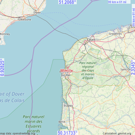
Wimille GPS coordinates[2]
50° 45' 51.048" North, 1° 37' 52.932" East
| Map corner | latitude | longitude |
|---|---|---|
| Upper-left | 51.2068°, | 0.92825° |
| Center: | 50.76418°, | 1.63137° |
| Lower-right: | 50.31733°, | 2.3345° |
| Map W x H: | 98.9×98.9 km | = 61.5×61.5mi |
| max Lat: | 51.07786° ⇑0.8% North |
| Wimille: | 50.76418° |
| min Lat: | ⇓99.2% South 41.3874° |
| min Long | Wimille | max Long |
| -5.08615° | 1.63137° | 9.52242° |
| W 38.7%⇐ | ⇒61.3% E |
Elevation
Elevation of Wimille is 13 m = 43 ft, and this is 180.7 m = 593 ft below average elevation for this country.
| Max E: |
2333 m = 7654 ft | 96.3% |
| Avg. | 193.7 m = 635 ft | |
| Wimille | 13 m = 43 ft | |
Min E: |
-1 m = -3 ft | 3.7% |
See also: France elevation on elevation.city.
Geographical zone
Wimille is located in North temperate zone (between Tropic of Cancer and the Arctic Circle). Distance of this North polar circle is 1756.7 km =1091.6 mi to North.| Distance of | km | miles | from Wimille |
|---|---|---|---|
| North Pole | 4362.6 | 2710.8 | to North |
| Arctic Circle | 1756.7 | 1091.6 | to North |
| Tropic Cancer | 3038.5 | 1888 | to South |
| Equator | 5644.4 | 3507.3 | to South |


Nearby cities:
15 places around Wimille: (largest is in red/bold)
• Ambleteuse
5.2 km =3.2 mi,  338°
338°
• Audresselles
7.2 km =4.5 mi, 338°
• Baincthun
7 km =4.3 mi,  150°
150°
• Belle-et-Houllefort
9.2 km =5.7 mi,  103°
103°
• Boulogne-sur-Mer
4.5 km =2.8 mi,  196°
196°
• La Capelle-lès-Boulogne
6 km =3.7 mi,  125°
125°
• Le Portel
7.6 km =4.7 mi,  211°
211°
• Marquise
7.6 km =4.7 mi,  44°
44°
• Outreau
7.2 km =4.5 mi, 204°
• Rinxent
8.4 km =5.2 mi,  55°
55°
• Saint-Léonard
8.2 km =5.1 mi,  182°
182°
• Saint-Martin-Boulogne
4.2 km =2.6 mi,  192°
192°
• Saint-Étienne-au-Mont
9.6 km =6 mi, 180°
• Wierre-Effroy
7.6 km =4.7 mi,  78°
78°
• Wimereux
1.5 km =0.9 mi,  293°
293°
Sources, notices
• [Note1] Compared only with cities in France existing in our database
• [Src1] Map data: © OpenStreetMap contributors (CC-BY-SA)
• [Src2] Other city data from geonames.org with taken over terms of usage.
• [Src3] Geographical zone / Annual Mean Temperature by Robert A. Rohde @ Wikipedia
