Outreau geodata
Outreau (Hauts-de-France) is a populated place; located in France in Europe/Paris (GMT+2) time zone. With population of 15,648 people, there are 616 cities with bigger population in this country. Compared to other cities in France, 98.9% of cities are located further ↓South; 61.8% of cities are located further →East and 78.2% of cities have higher elevation than Outreau. Note1
Administrative division(s):
- Level 1: Hauts-de-France
- Level 2: Pas-de-Calais
- Level 3: Arrondissement de Boulogne-sur-Mer
- Level 4: Outreau


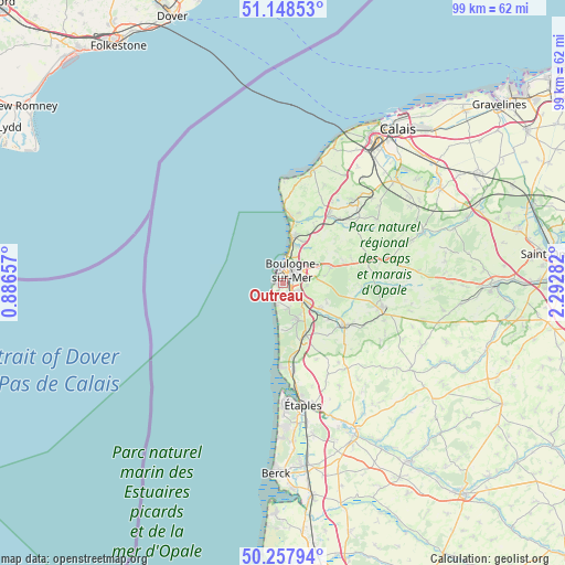
Outreau GPS coordinates[2]
50° 42' 19.26" North, 1° 35' 22.92" East
| Map corner | latitude | longitude |
|---|---|---|
| Upper-left | 51.14853°, | 0.88657° |
| Center: | 50.70535°, | 1.5897° |
| Lower-right: | 50.25794°, | 2.29282° |
| Map W x H: | 99×99 km | = 61.5×61.5mi |
| max Lat: | 51.07786° ⇑1.1% North |
| Outreau: | 50.70535° |
| min Lat: | ⇓98.9% South 41.3874° |
| min Long | Outreau | max Long |
| -5.08615° | 1.5897° | 9.52242° |
| W 38.2%⇐ | ⇒61.8% E |
Elevation
Elevation of Outreau is 59 m = 194 ft, and this is 134.7 m = 442 ft below average elevation for this country.
| Max E: |
2333 m = 7654 ft | 78.2% |
| Avg. | 193.7 m = 635 ft | |
| Outreau | 59 m = 194 ft | |
Min E: |
-1 m = -3 ft | 21.8% |
See also: France elevation on elevation.city.
Geographical zone
Outreau is located in North temperate zone (between Tropic of Cancer and the Arctic Circle). Distance of this North polar circle is 1763.3 km =1095.7 mi to North.| Distance of | km | miles | from Outreau |
|---|---|---|---|
| North Pole | 4369.2 | 2714.9 | to North |
| Arctic Circle | 1763.3 | 1095.7 | to North |
| Tropic Cancer | 3032 | 1884 | to South |
| Equator | 5637.9 | 3503.2 | to South |


Nearby cities:
15 places around Outreau: (largest is in red/bold)
• Baincthun
6.4 km =4 mi,  85°
85°
• Boulogne-sur-Mer
2.8 km =1.7 mi,  36°
36°
• Carly
9.9 km =6.2 mi,  126°
126°
• Condette
6.1 km =3.8 mi,  149°
149°
• Hesdigneul-lès-Boulogne
7.1 km =4.4 mi, 134°
• Isques
5.7 km =3.5 mi, 127°
• La Capelle-lès-Boulogne
8.4 km =5.2 mi,  68°
68°
• Le Portel
1 km =0.6 mi,  271°
271°
• Nesles
10 km =6.2 mi, 151°
• Saint-Léonard
3 km =1.9 mi,  123°
123°
• Saint-Martin-Boulogne
3.1 km =1.9 mi, 40°
• Saint-Étienne-au-Mont
4.2 km =2.6 mi,  136°
136°
• Wimereux
7.3 km =4.5 mi,  12°
12°
• Wimille
7.2 km =4.5 mi,  24°
24°
• Équihen-Plage
3.5 km =2.2 mi,  200°
200°
Sources, notices
• [Note1] Compared only with cities in France existing in our database
• [Src1] Map data: © OpenStreetMap contributors (CC-BY-SA)
• [Src2] Other city data from geonames.org with taken over terms of usage.
• [Src3] Geographical zone / Annual Mean Temperature by Robert A. Rohde @ Wikipedia
