Saint-Martin-Boulogne geodata
Saint-Martin-Boulogne (Hauts-de-France) is a populated place; located in France in Europe/Paris (GMT+2) time zone. With population of 12,414 people, there are 768 cities with bigger population in this country. Compared to other cities in France, 99% of cities are located further ↓South; 61.4% of cities are located further →East and 76.6% of cities have higher elevation than Saint-Martin-Boulogne. Note1
Administrative division(s):
- Level 1: Hauts-de-France
- Level 2: Pas-de-Calais
- Level 3: Arrondissement de Boulogne-sur-Mer
- Level 4: Saint-Martin-Boulogne
Current local time in Saint-Martin-Boulogne:
03:58 AM, SaturdayDifference from your time zone: hours


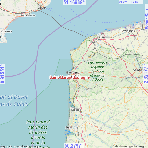
Saint-Martin-Boulogne GPS coordinates[2]
50° 43' 36.876" North, 1° 37' 7.104" East
| Map corner | latitude | longitude |
|---|---|---|
| Upper-left | 51.16989°, | 0.91551° |
| Center: | 50.72691°, | 1.61864° |
| Lower-right: | 50.2797°, | 2.32177° |
| Map W x H: | 99×99 km | = 61.5×61.5mi |
| max Lat: | 51.07786° ⇑1% North |
| Saint-Martin-Boulogne: | 50.72691° |
| min Lat: | ⇓99% South 41.3874° |
| min Long | Saint-Martin-Bo | max Long |
| -5.08615° | 1.61864° | 9.52242° |
| W 38.6%⇐ | ⇒61.4% E |
Elevation
Elevation of Saint-Martin-Boulogne is 63 m = 207 ft, and this is 130.7 m = 429 ft below average elevation for this country.
| Max E: |
2333 m = 7654 ft | 76.6% |
| Avg. | 193.7 m = 635 ft | |
| Saint-Martin-Boulogne | 63 m = 207 ft | |
Min E: |
-1 m = -3 ft | 23.4% |
See also: France elevation on elevation.city.
Geographical zone
Saint-Martin-Boulogne is located in North temperate zone (between Tropic of Cancer and the Arctic Circle). Distance of this North polar circle is 1760.9 km =1094.2 mi to North.| Distance of | km | miles | from Saint-Martin-Boulogne |
|---|---|---|---|
| North Pole | 4366.8 | 2713.4 | to North |
| Arctic Circle | 1760.9 | 1094.2 | to North |
| Tropic Cancer | 3034.4 | 1885.5 | to South |
| Equator | 5640.3 | 3504.7 | to South |


Nearby cities:
15 places around Saint-Martin-Boulogne: (largest is in red/bold)
• Ambleteuse
9 km =5.6 mi,  353°
353°
• Baincthun
4.8 km =3 mi,  113°
113°
• Belle-et-Houllefort
10 km =6.2 mi,  78°
78°
• Boulogne-sur-Mer
0.4 km =0.2 mi,  248°
248°
• Condette
7.7 km =4.8 mi,  172°
172°
• Hesdigneul-lès-Boulogne
7.9 km =4.9 mi,  157°
157°
• Isques
6.4 km =4 mi, 156°
• La Capelle-lès-Boulogne
5.9 km =3.7 mi, 83°
• Le Portel
3.8 km =2.4 mi,  231°
231°
• Outreau
3.1 km =1.9 mi,  220°
220°
• Saint-Léonard
4.1 km =2.5 mi, 173°
• Saint-Étienne-au-Mont
5.5 km =3.4 mi, 171°
• Wimereux
4.8 km =3 mi, 353°
• Wimille
4.2 km =2.6 mi,  12°
12°
• Équihen-Plage
6.6 km =4.1 mi,  209°
209°
Sources, notices
• [Note1] Compared only with cities in France existing in our database
• [Src1] Map data: © OpenStreetMap contributors (CC-BY-SA)
• [Src2] Other city data from geonames.org with taken over terms of usage.
• [Src3] Geographical zone / Annual Mean Temperature by Robert A. Rohde @ Wikipedia
