Baincthun geodata
Baincthun (Hauts-de-France) is a populated place; located in France in Europe/Paris (GMT+2) time zone. With population of 1,340 people, there are 6864 cities with bigger population in this country. Compared to other cities in France, 98.9% of cities are located further ↓South; 60.7% of cities are located further →East and 88.3% of cities have higher elevation than Baincthun. Note1
Administrative division(s):
- Level 1: Hauts-de-France
- Level 2: Pas-de-Calais
- Level 3: Arrondissement de Boulogne-sur-Mer
- Level 4: Baincthun


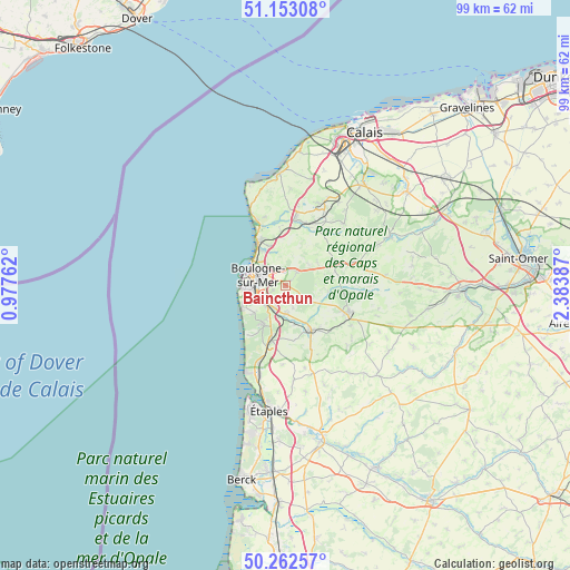
Baincthun GPS coordinates[2]
50° 42' 35.784" North, 1° 40' 50.7" East
| Map corner | latitude | longitude |
|---|---|---|
| Upper-left | 51.15308°, | 0.97762° |
| Center: | 50.70994°, | 1.68075° |
| Lower-right: | 50.26257°, | 2.38387° |
| Map W x H: | 99×99 km | = 61.5×61.5mi |
| max Lat: | 51.07786° ⇑1.1% North |
| Baincthun: | 50.70994° |
| min Lat: | ⇓98.9% South 41.3874° |
| min Long | Baincthun | max Long |
| -5.08615° | 1.68075° | 9.52242° |
| W 39.3%⇐ | ⇒60.7% E |
Elevation
Elevation of Baincthun is 34 m = 112 ft, and this is 159.7 m = 524 ft below average elevation for this country.
| Max E: |
2333 m = 7654 ft | 88.3% |
| Avg. | 193.7 m = 635 ft | |
| Baincthun | 34 m = 112 ft | |
Min E: |
-1 m = -3 ft | 11.7% |
See also: France elevation on elevation.city.
Geographical zone
Baincthun is located in North temperate zone (between Tropic of Cancer and the Arctic Circle). Distance of this North polar circle is 1762.8 km =1095.4 mi to North.| Distance of | km | miles | from Baincthun |
|---|---|---|---|
| North Pole | 4368.6 | 2714.5 | to North |
| Arctic Circle | 1762.8 | 1095.4 | to North |
| Tropic Cancer | 3032.5 | 1884.3 | to South |
| Equator | 5638.4 | 3503.5 | to South |


Nearby cities:
15 places around Baincthun: (largest is in red/bold)
• Belle-et-Houllefort
6.7 km =4.2 mi,  55°
55°
• Boulogne-sur-Mer
5 km =3.1 mi,  290°
290°
• Carly
6.7 km =4.2 mi,  166°
166°
• Condette
6.6 km =4.1 mi,  209°
209°
• Crémarest
7.4 km =4.6 mi,  98°
98°
• Hesdigneul-lès-Boulogne
5.6 km =3.5 mi,  193°
193°
• Isques
4.4 km =2.7 mi,  204°
204°
• La Capelle-lès-Boulogne
3 km =1.9 mi,  29°
29°
• Le Portel
7.4 km =4.6 mi,  266°
266°
• Outreau
6.4 km =4 mi, 265°
• Saint-Léonard
4.5 km =2.8 mi,  241°
241°
• Saint-Martin-Boulogne
4.8 km =3 mi, 293°
• Saint-Étienne-au-Mont
5 km =3.1 mi,  224°
224°
• Wimille
7 km =4.3 mi,  330°
330°
• Wirwignes
6.3 km =3.9 mi,  116°
116°
Sources, notices
• [Note1] Compared only with cities in France existing in our database
• [Src1] Map data: © OpenStreetMap contributors (CC-BY-SA)
• [Src2] Other city data from geonames.org with taken over terms of usage.
• [Src3] Geographical zone / Annual Mean Temperature by Robert A. Rohde @ Wikipedia
