Wandignies-Hamage geodata
Wandignies-Hamage (Hauts-de-France) is a populated place; located in France in Europe/Paris (GMT+2) time zone. With population of 1,155 people, there are 7796 cities with bigger population in this country. Compared to other cities in France, 96.4% of cities are located further ↓South; 62.2% of cities are located further ←West and 95.7% of cities have higher elevation than Wandignies-Hamage. Note1
Administrative division(s):
- Level 1: Hauts-de-France
- Level 2: Nord
- Level 3: Arrondissement de Douai
- Level 4: Wandignies-Hamage


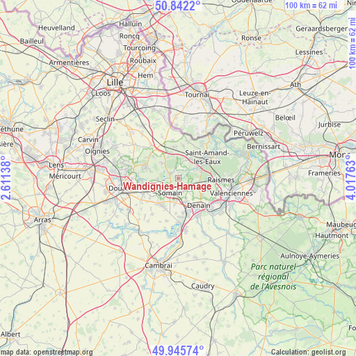
Wandignies-Hamage GPS coordinates[2]
50° 23' 45.924" North, 3° 18' 52.2" East
| Map corner | latitude | longitude |
|---|---|---|
| Upper-left | 50.8422°, | 2.61138° |
| Center: | 50.39609°, | 3.3145° |
| Lower-right: | 49.94574°, | 4.01763° |
| Map W x H: | 99.7×99.7 km | = 62×62mi |
| max Lat: | 51.07786° ⇑3.6% North |
| Wandignies-Hamage: | 50.39609° |
| min Lat: | ⇓96.4% South 41.3874° |
| min Long | Wandignies-Hama | max Long |
| -5.08615° | 3.3145° | 9.52242° |
| W 62.2%⇐ | ⇒37.8% E |
Elevation
Elevation of Wandignies-Hamage is 15 m = 49 ft, and this is 178.7 m = 586 ft below average elevation for this country.
| Max E: |
2333 m = 7654 ft | 95.7% |
| Avg. | 193.7 m = 635 ft | |
| Wandignies-Hamage | 15 m = 49 ft | |
Min E: |
-1 m = -3 ft | 4.3% |
See also: France elevation on elevation.city.
Geographical zone
Wandignies-Hamage is located in North temperate zone (between Tropic of Cancer and the Arctic Circle). Distance of this North polar circle is 1797.7 km =1117 mi to North.| Distance of | km | miles | from Wandignies-Hamage |
|---|---|---|---|
| North Pole | 4403.5 | 2736.2 | to North |
| Arctic Circle | 1797.7 | 1117 | to North |
| Tropic Cancer | 2997.6 | 1862.6 | to South |
| Equator | 5603.5 | 3481.9 | to South |


Nearby cities:
15 places around Wandignies-Hamage: (largest is in red/bold)
• Abscon
7.1 km =4.4 mi,  188°
188°
• Bouvignies
6.7 km =4.2 mi,  311°
311°
• Brillon
4.4 km =2.7 mi,  13°
13°
• Bruille-lez-Marchiennes
6.3 km =3.9 mi,  231°
231°
• Erre
3.7 km =2.3 mi,  178°
178°
• Fenain
3.4 km =2.1 mi,  197°
197°
• Hasnon
6 km =3.7 mi,  58°
58°
• Hornaing
3.5 km =2.2 mi,  152°
152°
• Hélesmes
4.3 km =2.7 mi,  132°
132°
• Marchiennes
2.3 km =1.4 mi,  281°
281°
• Millonfosse
7.3 km =4.5 mi,  54°
54°
• Rieulay
4.8 km =3 mi,  245°
245°
• Somain
4.7 km =2.9 mi,  210°
210°
• Vred
6 km =3.7 mi,  268°
268°
• Wallers
6 km =3.7 mi,  113°
113°
Sources, notices
• [Note1] Compared only with cities in France existing in our database
• [Src1] Map data: © OpenStreetMap contributors (CC-BY-SA)
• [Src2] Other city data from geonames.org with taken over terms of usage.
• [Src3] Geographical zone / Annual Mean Temperature by Robert A. Rohde @ Wikipedia
