Abscon geodata
Abscon (Hauts-de-France) is a populated place; located in France in Europe/Paris (GMT+2) time zone. With population of 4,204 people, there are 2340 cities with bigger population in this country. Compared to other cities in France, 95.9% of cities are located further ↓South; 62% of cities are located further ←West and 79% of cities have higher elevation than Abscon. Note1
Administrative division(s):
- Level 1: Hauts-de-France
- Level 2: Nord
- Level 3: Arrondissement de Valenciennes
- Level 4: Abscon


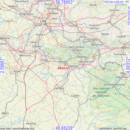
Abscon GPS coordinates[2]
50° 19' 59.988" North, 3° 18' 0" East
| Map corner | latitude | longitude |
|---|---|---|
| Upper-left | 50.78003°, | 2.59687° |
| Center: | 50.33333°, | 3.3° |
| Lower-right: | 49.88239°, | 4.00312° |
| Map W x H: | 99.8×99.8 km | = 62×62mi |
| max Lat: | 51.07786° ⇑4.1% North |
| Abscon: | 50.33333° |
| min Lat: | ⇓95.9% South 41.3874° |
| min Long | Abscon | max Long |
| -5.08615° | 3.3° | 9.52242° |
| W 62%⇐ | ⇒38% E |
Elevation
Elevation of Abscon is 57 m = 187 ft, and this is 136.7 m = 448 ft below average elevation for this country.
| Max E: |
2333 m = 7654 ft | 79% |
| Avg. | 193.7 m = 635 ft | |
| Abscon | 57 m = 187 ft | |
Min E: |
-1 m = -3 ft | 21% |
See also: France elevation on elevation.city.
Geographical zone
Abscon is located in North temperate zone (between Tropic of Cancer and the Arctic Circle). Distance of this North polar circle is 1804.6 km =1121.3 mi to North.| Distance of | km | miles | from Abscon |
|---|---|---|---|
| North Pole | 4410.5 | 2740.6 | to North |
| Arctic Circle | 1804.6 | 1121.3 | to North |
| Tropic Cancer | 2990.6 | 1858.3 | to South |
| Equator | 5596.5 | 3477.5 | to South |


Nearby cities:
15 places around Abscon: (largest is in red/bold)
• Aniche
3.3 km =2.1 mi,  263°
263°
• Auberchicourt
4.7 km =2.9 mi,  270°
270°
• Bouchain
5.5 km =3.4 mi,  168°
168°
• Bruille-lez-Marchiennes
5 km =3.1 mi,  307°
307°
• Erre
3.4 km =2.1 mi,  18°
18°
• Escaudain
3.1 km =1.9 mi,  90°
90°
• Fenain
3.7 km =2.3 mi,  0°
0°
• Hornaing
4.7 km =2.9 mi,  34°
34°
• Hélesmes
5.9 km =3.7 mi,  45°
45°
• Lourches
4.3 km =2.7 mi,  120°
120°
• Mastaing
3 km =1.9 mi, 173°
• Neuville-sur-Escaut
5.1 km =3.2 mi,  136°
136°
• Rœulx
4.4 km =2.7 mi,  147°
147°
• Somain
3.2 km =2 mi,  335°
335°
• Émerchicourt
4.8 km =3 mi,  233°
233°
Sources, notices
• [Note1] Compared only with cities in France existing in our database
• [Src1] Map data: © OpenStreetMap contributors (CC-BY-SA)
• [Src2] Other city data from geonames.org with taken over terms of usage.
• [Src3] Geographical zone / Annual Mean Temperature by Robert A. Rohde @ Wikipedia
