Hasnon geodata
Hasnon (Hauts-de-France) is a populated place; located in France in Europe/Paris (GMT+2) time zone. With population of 3,248 people, there are 3006 cities with bigger population in this country. Compared to other cities in France, 96.7% of cities are located further ↓South; 63% of cities are located further ←West and 95.4% of cities have higher elevation than Hasnon. Note1
Administrative division(s):
- Level 1: Hauts-de-France
- Level 2: Nord
- Level 3: Arrondissement de Valenciennes
- Level 4: Hasnon


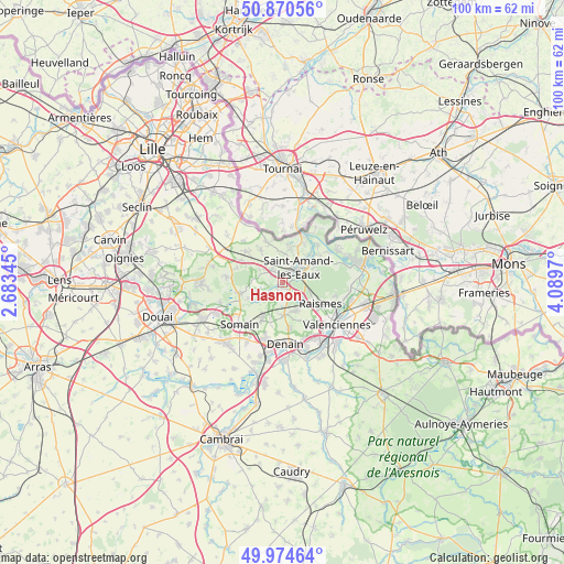
Hasnon GPS coordinates[2]
50° 25' 28.992" North, 3° 23' 11.652" East
| Map corner | latitude | longitude |
|---|---|---|
| Upper-left | 50.87056°, | 2.68345° |
| Center: | 50.42472°, | 3.38657° |
| Lower-right: | 49.97464°, | 4.0897° |
| Map W x H: | 99.6×99.6 km | = 61.9×61.9mi |
| max Lat: | 51.07786° ⇑3.3% North |
| Hasnon: | 50.42472° |
| min Lat: | ⇓96.7% South 41.3874° |
| min Long | Hasnon | max Long |
| -5.08615° | 3.38657° | 9.52242° |
| W 63%⇐ | ⇒37% E |
Elevation
Elevation of Hasnon is 16 m = 52 ft, and this is 177.7 m = 583 ft below average elevation for this country.
| Max E: |
2333 m = 7654 ft | 95.4% |
| Avg. | 193.7 m = 635 ft | |
| Hasnon | 16 m = 52 ft | |
Min E: |
-1 m = -3 ft | 4.6% |
See also: France elevation on elevation.city.
Geographical zone
Hasnon is located in North temperate zone (between Tropic of Cancer and the Arctic Circle). Distance of this North polar circle is 1794.5 km =1115.1 mi to North.| Distance of | km | miles | from Hasnon |
|---|---|---|---|
| North Pole | 4400.4 | 2734.3 | to North |
| Arctic Circle | 1794.5 | 1115.1 | to North |
| Tropic Cancer | 3000.8 | 1864.6 | to South |
| Equator | 5606.7 | 3483.8 | to South |


Nearby cities:
15 places around Hasnon: (largest is in red/bold)
• Bellaing
6.9 km =4.3 mi,  156°
156°
• Brillon
4.2 km =2.6 mi,  285°
285°
• Hornaing
7.2 km =4.5 mi,  209°
209°
• Hélesmes
6.3 km =3.9 mi,  197°
197°
• Landas
7.9 km =4.9 mi,  312°
312°
• Lecelles
4.9 km =3 mi,  12°
12°
• Marchiennes
7.8 km =4.8 mi,  249°
249°
• Millonfosse
1.3 km =0.8 mi,  35°
35°
• Rosult
4.3 km =2.7 mi,  332°
332°
• Rumegies
7.5 km =4.7 mi,  340°
340°
• Saint-Amand-les-Eaux
4 km =2.5 mi,  51°
51°
• Saméon
6.3 km =3.9 mi, 325°
• Thun-Saint-Amand
7 km =4.3 mi, 40°
• Wallers
5.6 km =3.5 mi,  176°
176°
• Wandignies-Hamage
6 km =3.7 mi,  238°
238°
Sources, notices
• [Note1] Compared only with cities in France existing in our database
• [Src1] Map data: © OpenStreetMap contributors (CC-BY-SA)
• [Src2] Other city data from geonames.org with taken over terms of usage.
• [Src3] Geographical zone / Annual Mean Temperature by Robert A. Rohde @ Wikipedia
