Wancourt geodata
Wancourt (Hauts-de-France) is a populated place; located in France in Europe/Paris (GMT+2) time zone. With population of 603 people, there are 13268 cities with bigger population in this country. Compared to other cities in France, 95% of cities are located further ↓South; 56% of cities are located further ←West and 75% of cities have higher elevation than Wancourt. Note1
Administrative division(s):
- Level 1: Hauts-de-France
- Level 2: Pas-de-Calais
- Level 3: Arras
- Level 4: Wancourt


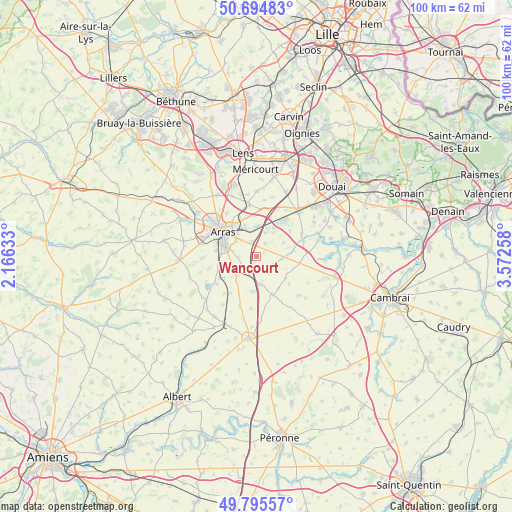
Wancourt GPS coordinates[2]
50° 14' 50.352" North, 2° 52' 10.02" East
| Map corner | latitude | longitude |
|---|---|---|
| Upper-left | 50.69483°, | 2.16633° |
| Center: | 50.24732°, | 2.86945° |
| Lower-right: | 49.79557°, | 3.57258° |
| Map W x H: | 100×100 km | = 62.1×62.1mi |
| max Lat: | 51.07786° ⇑5% North |
| Wancourt: | 50.24732° |
| min Lat: | ⇓95% South 41.3874° |
| min Long | Wancourt | max Long |
| -5.08615° | 2.86945° | 9.52242° |
| W 56%⇐ | ⇒44% E |
Elevation
Elevation of Wancourt is 67 m = 220 ft, and this is 126.7 m = 416 ft below average elevation for this country.
| Max E: |
2333 m = 7654 ft | 75% |
| Avg. | 193.7 m = 635 ft | |
| Wancourt | 67 m = 220 ft | |
Min E: |
-1 m = -3 ft | 25% |
See also: France elevation on elevation.city.
Geographical zone
Wancourt is located in North temperate zone (between Tropic of Cancer and the Arctic Circle). Distance of this North polar circle is 1814.2 km =1127.3 mi to North.| Distance of | km | miles | from Wancourt |
|---|---|---|---|
| North Pole | 4420.1 | 2746.5 | to North |
| Arctic Circle | 1814.2 | 1127.3 | to North |
| Tropic Cancer | 2981.1 | 1852.4 | to South |
| Equator | 5587 | 3471.6 | to South |


Nearby cities:
15 places around Wancourt: (largest is in red/bold)
• Agny
7.9 km =4.9 mi,  279°
279°
• Arras
8 km =5 mi,  309°
309°
• Athies
6.5 km =4 mi,  339°
339°
• Beaurains
5.7 km =3.5 mi,  291°
291°
• Croisilles
5.3 km =3.3 mi,  172°
172°
• Fampoux
6.1 km =3.8 mi,  2°
2°
• Feuchy
5.6 km =3.5 mi, 340°
• Mercatel
5.4 km =3.4 mi,  255°
255°
• Monchy-le-Preux
3.1 km =1.9 mi,  33°
33°
• Neuville-Vitasse
3.5 km =2.2 mi,  271°
271°
• Pelves
5.7 km =3.5 mi, 33°
• Rœux
5.8 km =3.6 mi,  22°
22°
• Saint-Laurent-Blangy
6.9 km =4.3 mi,  319°
319°
• Tilloy-lès-Mofflaines
5 km =3.1 mi, 308°
• Vis-en-Artois
5 km =3.1 mi,  89°
89°
Sources, notices
• [Note1] Compared only with cities in France existing in our database
• [Src1] Map data: © OpenStreetMap contributors (CC-BY-SA)
• [Src2] Other city data from geonames.org with taken over terms of usage.
• [Src3] Geographical zone / Annual Mean Temperature by Robert A. Rohde @ Wikipedia
