Fampoux geodata
Fampoux (Hauts-de-France) is a populated place; located in France in Europe/Paris (GMT+2) time zone. With population of 1,107 people, there are 8081 cities with bigger population in this country. Compared to other cities in France, 95.6% of cities are located further ↓South; 56.1% of cities are located further ←West and 81.5% of cities have higher elevation than Fampoux. Note1
Administrative division(s):
- Level 1: Hauts-de-France
- Level 2: Pas-de-Calais
- Level 3: Arras
- Level 4: Fampoux


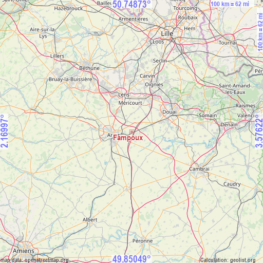
Fampoux GPS coordinates[2]
50° 18' 6.228" North, 2° 52' 23.16" East
| Map corner | latitude | longitude |
|---|---|---|
| Upper-left | 50.74873°, | 2.16997° |
| Center: | 50.30173°, | 2.8731° |
| Lower-right: | 49.85049°, | 3.57622° |
| Map W x H: | 99.9×99.9 km | = 62.1×62.1mi |
| max Lat: | 51.07786° ⇑4.4% North |
| Fampoux: | 50.30173° |
| min Lat: | ⇓95.6% South 41.3874° |
| min Long | Fampoux | max Long |
| -5.08615° | 2.8731° | 9.52242° |
| W 56.1%⇐ | ⇒43.9% E |
Elevation
Elevation of Fampoux is 51 m = 167 ft, and this is 142.7 m = 468 ft below average elevation for this country.
| Max E: |
2333 m = 7654 ft | 81.5% |
| Avg. | 193.7 m = 635 ft | |
| Fampoux | 51 m = 167 ft | |
Min E: |
-1 m = -3 ft | 18.5% |
See also: France elevation on elevation.city.
Geographical zone
Fampoux is located in North temperate zone (between Tropic of Cancer and the Arctic Circle). Distance of this North polar circle is 1808.1 km =1123.5 mi to North.| Distance of | km | miles | from Fampoux |
|---|---|---|---|
| North Pole | 4414 | 2742.7 | to North |
| Arctic Circle | 1808.1 | 1123.5 | to North |
| Tropic Cancer | 2987.1 | 1856.1 | to South |
| Equator | 5593 | 3475.3 | to South |


Nearby cities:
15 places around Fampoux: (largest is in red/bold)
• Arras
6.6 km =4.1 mi,  261°
261°
• Athies
2.5 km =1.6 mi,  269°
269°
• Bailleul-Sir-Berthoult
4.3 km =2.7 mi,  338°
338°
• Beaurains
6.8 km =4.2 mi,  234°
234°
• Biache-Saint-Vaast
5.4 km =3.4 mi,  81°
81°
• Feuchy
2.3 km =1.4 mi,  248°
248°
• Monchy-le-Preux
3.8 km =2.4 mi,  157°
157°
• Pelves
3.1 km =1.9 mi,  113°
113°
• Roclincourt
6.7 km =4.2 mi,  293°
293°
• Rœux
2.1 km =1.3 mi, 110°
• Saint-Laurent-Blangy
4.8 km =3 mi, 260°
• Saint-Nicolas
6.7 km =4.2 mi, 272°
• Tilloy-lès-Mofflaines
5.1 km =3.2 mi, 234°
• Wancourt
6.1 km =3.8 mi,  182°
182°
• Willerval
6.4 km =4 mi, 341°
Sources, notices
• [Note1] Compared only with cities in France existing in our database
• [Src1] Map data: © OpenStreetMap contributors (CC-BY-SA)
• [Src2] Other city data from geonames.org with taken over terms of usage.
• [Src3] Geographical zone / Annual Mean Temperature by Robert A. Rohde @ Wikipedia
