Vue geodata
Vue (Pays de la Loire) is a populated place; located in France in Europe/Paris (GMT+2) time zone. With population of 1,324 people, there are 6924 cities with bigger population in this country. Compared to other cities in France, 53% of cities are located further ↑North; 94.4% of cities are located further →East and 96.7% of cities have higher elevation than Vue. Note1
Administrative division(s):
- Level 1: Pays de la Loire
- Level 2: Loire-Atlantique
- Level 3: Arrondissement de Nantes
- Level 4: Vue


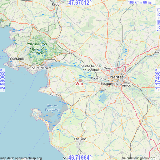
Vue GPS coordinates[2]
47° 11' 58.308" North, 1° 52' 39" West
| Map corner | latitude | longitude |
|---|---|---|
| Upper-left | 47.67512°, | -2.58063° |
| Center: | 47.19953°, | -1.8775° |
| Lower-right: | 46.71964°, | -1.17438° |
| Map W x H: | 106.2×106.2 km | = 66×66mi |
| max Lat: | 51.07786° ⇑53% North |
| Vue: | 47.19953° |
| min Lat: | ⇓47% South 41.3874° |
| min Long | Vue | max Long |
| -5.08615° | -1.8775° | 9.52242° |
| W 5.6%⇐ | ⇒94.4% E |
Elevation
Elevation of Vue is 12 m = 39 ft, and this is 181.7 m = 596 ft below average elevation for this country.
| Max E: |
2333 m = 7654 ft | 96.7% |
| Avg. | 193.7 m = 635 ft | |
| Vue | 12 m = 39 ft | |
Min E: |
-1 m = -3 ft | 3.3% |
See also: France elevation on elevation.city.
Geographical zone
Vue is located in North temperate zone (between Tropic of Cancer and the Arctic Circle). Distance of this North polar circle is 2153.1 km =1337.9 mi to North.| Distance of | km | miles | from Vue |
|---|---|---|---|
| North Pole | 4759 | 2957.1 | to North |
| Arctic Circle | 2153.1 | 1337.9 | to North |
| Tropic Cancer | 2642.2 | 1641.8 | to South |
| Equator | 5248.1 | 3261 | to South |


Nearby cities:
15 places around Vue: (largest is in red/bold)
• Arthon-en-Retz
10.5 km =6.5 mi,  207°
207°
• Brains
12.2 km =7.6 mi,  106°
106°
• Chauvé
9.7 km =6 mi,  236°
236°
• Cheix-en-Retz
5.2 km =3.2 mi, 112°
• Chéméré
9.7 km =6 mi,  197°
197°
• Cordemais
10.2 km =6.3 mi,  359°
359°
• Couëron
11.9 km =7.4 mi,  81°
81°
• Frossay
6.7 km =4.2 mi,  318°
318°
• Le Pellerin
9.2 km =5.7 mi,  90°
90°
• Port-Saint-Père
12.2 km =7.6 mi,  127°
127°
• Rouans
2.3 km =1.4 mi,  142°
142°
• Saint-Hilaire-de-Chaléons
10.9 km =6.8 mi,  175°
175°
• Saint-Jean-de-Boiseau
11.7 km =7.3 mi, 93°
• Saint-Étienne-de-Montluc
11.3 km =7 mi,  40°
40°
• Sainte-Pazanne
11.9 km =7.4 mi,  154°
154°
Sources, notices
• [Note1] Compared only with cities in France existing in our database
• [Src1] Map data: © OpenStreetMap contributors (CC-BY-SA)
• [Src2] Other city data from geonames.org with taken over terms of usage.
• [Src3] Geographical zone / Annual Mean Temperature by Robert A. Rohde @ Wikipedia
