Cordemais geodata
Cordemais (Pays de la Loire) is a populated place; located in France in Europe/Paris (GMT+2) time zone. With population of 2,747 people, there are 3564 cities with bigger population in this country. Compared to other cities in France, 51.6% of cities are located further ↑North; 94.4% of cities are located further →East and 95.4% of cities have higher elevation than Cordemais. Note1
Administrative division(s):
- Level 1: Pays de la Loire
- Level 2: Loire-Atlantique
- Level 3: Arrondissement de Nantes
- Level 4: Cordemais


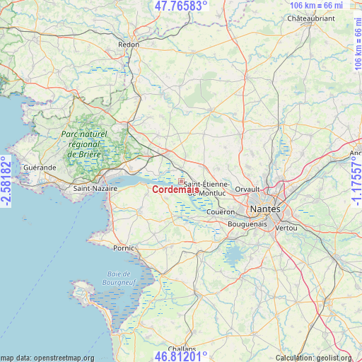
Cordemais GPS coordinates[2]
47° 17' 27.852" North, 1° 52' 43.284" West
| Map corner | latitude | longitude |
|---|---|---|
| Upper-left | 47.76583°, | -2.58182° |
| Center: | 47.29107°, | -1.87869° |
| Lower-right: | 46.81201°, | -1.17557° |
| Map W x H: | 106.1×106.1 km | = 65.9×65.9mi |
| max Lat: | 51.07786° ⇑51.6% North |
| Cordemais: | 47.29107° |
| min Lat: | ⇓48.4% South 41.3874° |
| min Long | Cordemais | max Long |
| -5.08615° | -1.87869° | 9.52242° |
| W 5.6%⇐ | ⇒94.4% E |
Elevation
Elevation of Cordemais is 16 m = 52 ft, and this is 177.7 m = 583 ft below average elevation for this country.
| Max E: |
2333 m = 7654 ft | 95.4% |
| Avg. | 193.7 m = 635 ft | |
| Cordemais | 16 m = 52 ft | |
Min E: |
-1 m = -3 ft | 4.6% |
See also: France elevation on elevation.city.
Geographical zone
Cordemais is located in North temperate zone (between Tropic of Cancer and the Arctic Circle). Distance of this North polar circle is 2142.9 km =1331.5 mi to North.| Distance of | km | miles | from Cordemais |
|---|---|---|---|
| North Pole | 4748.8 | 2950.8 | to North |
| Arctic Circle | 2142.9 | 1331.5 | to North |
| Tropic Cancer | 2652.4 | 1648.1 | to South |
| Equator | 5258.3 | 3267.4 | to South |


Nearby cities:
15 places around Cordemais: (largest is in red/bold)
• Bouée
4 km =2.5 mi,  323°
323°
• Cheix-en-Retz
13.1 km =8.1 mi,  158°
158°
• Frossay
6.7 km =4.2 mi,  219°
219°
• La Chapelle-Launay
11.4 km =7.1 mi, 322°
• Lavau-sur-Loire
6.8 km =4.2 mi,  285°
285°
• Le Temple-de-Bretagne
7.9 km =4.9 mi,  59°
59°
• Malville
7.7 km =4.8 mi,  9°
9°
• Paimboeuf
11.5 km =7.1 mi,  267°
267°
• Prinquiau
12.6 km =7.8 mi,  308°
308°
• Rouans
12.1 km =7.5 mi,  173°
173°
• Saint-Viaud
11.2 km =7 mi,  249°
249°
• Saint-Étienne-de-Montluc
7.6 km =4.7 mi,  102°
102°
• Savenay
9.1 km =5.7 mi,  328°
328°
• Vigneux-de-Bretagne
11.4 km =7.1 mi,  70°
70°
• Vue
10.2 km =6.3 mi,  179°
179°
Sources, notices
• [Note1] Compared only with cities in France existing in our database
• [Src1] Map data: © OpenStreetMap contributors (CC-BY-SA)
• [Src2] Other city data from geonames.org with taken over terms of usage.
• [Src3] Geographical zone / Annual Mean Temperature by Robert A. Rohde @ Wikipedia
