Chauvé geodata
Chauvé (Pays de la Loire) is a populated place; located in France in Europe/Paris (GMT+2) time zone. With population of 1,822 people, there are 5209 cities with bigger population in this country. Compared to other cities in France, 53.6% of cities are located further ↑North; 94.8% of cities are located further →East and 89.5% of cities have higher elevation than Chauvé. Note1
Administrative division(s):
- Level 1: Pays de la Loire
- Level 2: Loire-Atlantique
- Level 3: Arrondissement de Saint-Nazaire
- Level 4: Chauvé


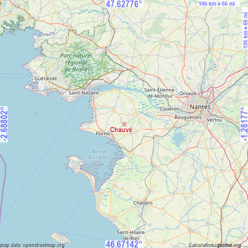
Chauvé GPS coordinates[2]
47° 9' 6.264" North, 1° 59' 5.604" West
| Map corner | latitude | longitude |
|---|---|---|
| Upper-left | 47.62776°, | -2.68802° |
| Center: | 47.15174°, | -1.98489° |
| Lower-right: | 46.67142°, | -1.28177° |
| Map W x H: | 106.3×106.3 km | = 66.1×66.1mi |
| max Lat: | 51.07786° ⇑53.6% North |
| Chauvé: | 47.15174° |
| min Lat: | ⇓46.4% South 41.3874° |
| min Long | Chauvé | max Long |
| -5.08615° | -1.98489° | 9.52242° |
| W 5.2%⇐ | ⇒94.8% E |
Elevation
Elevation of Chauvé is 31 m = 102 ft, and this is 162.7 m = 534 ft below average elevation for this country.
| Max E: |
2333 m = 7654 ft | 89.5% |
| Avg. | 193.7 m = 635 ft | |
| Chauvé | 31 m = 102 ft | |
Min E: |
-1 m = -3 ft | 10.5% |
See also: France elevation on elevation.city.
Geographical zone
Chauvé is located in North temperate zone (between Tropic of Cancer and the Arctic Circle). Distance of this North polar circle is 2158.4 km =1341.2 mi to North.| Distance of | km | miles | from Chauvé |
|---|---|---|---|
| North Pole | 4764.3 | 2960.4 | to North |
| Arctic Circle | 2158.4 | 1341.2 | to North |
| Tropic Cancer | 2636.9 | 1638.5 | to South |
| Equator | 5242.8 | 3257.7 | to South |


Nearby cities:
15 places around Chauvé: (largest is in red/bold)
• Arthon-en-Retz
5.1 km =3.2 mi,  141°
141°
• Bourgneuf-en-Retz
12.6 km =7.8 mi,  167°
167°
• Cheix-en-Retz
13.3 km =8.3 mi,  75°
75°
• Chéméré
6.5 km =4 mi,  127°
127°
• Frossay
11 km =6.8 mi,  19°
19°
• La Bernerie-en-Retz
8.8 km =5.5 mi,  206°
206°
• Les Moutiers-en-Retz
9.8 km =6.1 mi,  186°
186°
• Pornic
9 km =5.6 mi,  240°
240°
• Rouans
10.1 km =6.3 mi,  69°
69°
• Saint-Hilaire-de-Chaléons
10.5 km =6.5 mi,  121°
121°
• Saint-Michel-Chef-Chef
12.8 km =8 mi,  284°
284°
• Saint-Père-en-Retz
7.3 km =4.5 mi,  324°
324°
• Saint-Viaud
11.9 km =7.4 mi,  347°
347°
• Sainte-Pazanne
14.3 km =8.9 mi,  112°
112°
• Vue
9.7 km =6 mi,  56°
56°
Sources, notices
• [Note1] Compared only with cities in France existing in our database
• [Src1] Map data: © OpenStreetMap contributors (CC-BY-SA)
• [Src2] Other city data from geonames.org with taken over terms of usage.
• [Src3] Geographical zone / Annual Mean Temperature by Robert A. Rohde @ Wikipedia
