Vron geodata
Vron (Hauts-de-France) is a populated place; located in France in Europe/Paris (GMT+2) time zone. With population of 733 people, there are 11372 cities with bigger population in this country. Compared to other cities in France, 95.7% of cities are located further ↓South; 59.9% of cities are located further →East and 93.9% of cities have higher elevation than Vron. Note1
Administrative division(s):
- Level 1: Hauts-de-France
- Level 2: Somme
- Level 3: Abbeville
- Level 4: Vron


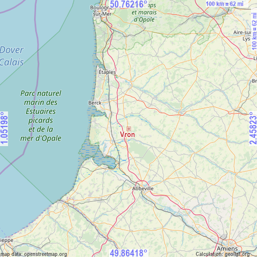
Vron GPS coordinates[2]
50° 18' 55.044" North, 1° 45' 18.36" East
| Map corner | latitude | longitude |
|---|---|---|
| Upper-left | 50.76216°, | 1.05198° |
| Center: | 50.31529°, | 1.7551° |
| Lower-right: | 49.86418°, | 2.45823° |
| Map W x H: | 99.8×99.8 km | = 62×62mi |
| max Lat: | 51.07786° ⇑4.3% North |
| Vron: | 50.31529° |
| min Lat: | ⇓95.7% South 41.3874° |
| min Long | Vron | max Long |
| -5.08615° | 1.7551° | 9.52242° |
| W 40.1%⇐ | ⇒59.9% E |
Elevation
Elevation of Vron is 20 m = 66 ft, and this is 173.7 m = 570 ft below average elevation for this country.
| Max E: |
2333 m = 7654 ft | 93.9% |
| Avg. | 193.7 m = 635 ft | |
| Vron | 20 m = 66 ft | |
Min E: |
-1 m = -3 ft | 6.1% |
See also: France elevation on elevation.city.
Geographical zone
Vron is located in North temperate zone (between Tropic of Cancer and the Arctic Circle). Distance of this North polar circle is 1806.6 km =1122.6 mi to North.| Distance of | km | miles | from Vron |
|---|---|---|---|
| North Pole | 4412.5 | 2741.8 | to North |
| Arctic Circle | 1806.6 | 1122.6 | to North |
| Tropic Cancer | 2988.6 | 1857 | to South |
| Equator | 5594.5 | 3476.3 | to South |


Nearby cities:
15 places around Vron: (largest is in red/bold)
• Buire-le-Sec
9.4 km =5.8 mi,  35°
35°
• Campagne-lès-Hesdin
12.5 km =7.8 mi, 43°
• Conchil-le-Temple
8.8 km =5.5 mi,  312°
312°
• Crécy-en-Ponthieu
11.4 km =7.1 mi,  128°
128°
• Fort-Mahon-Plage
14.1 km =8.8 mi,  281°
281°
• Gouy-Saint-André
12.2 km =7.6 mi,  56°
56°
• Groffliers
12.6 km =7.8 mi, 307°
• Le Crotoy
14.4 km =8.9 mi,  219°
219°
• Nouvion
13 km =8.1 mi,  171°
171°
• Ponthoile
11.7 km =7.3 mi,  195°
195°
• Quend
8.5 km =5.3 mi,  270°
270°
• Rang-du-Fliers
13.8 km =8.6 mi,  325°
325°
• Rue
7.7 km =4.8 mi,  230°
230°
• Verton
12.3 km =7.6 mi,  321°
321°
• Wailly-Beaucamp
10.8 km =6.7 mi,  349°
349°
Sources, notices
• [Note1] Compared only with cities in France existing in our database
• [Src1] Map data: © OpenStreetMap contributors (CC-BY-SA)
• [Src2] Other city data from geonames.org with taken over terms of usage.
• [Src3] Geographical zone / Annual Mean Temperature by Robert A. Rohde @ Wikipedia
