Ponthoile geodata
Ponthoile (Hauts-de-France) is a populated place; located in France in Europe/Paris (GMT+2) time zone. With population of 556 people, there are 14098 cities with bigger population in this country. Compared to other cities in France, 94.9% of cities are located further ↓South; 60.3% of cities are located further →East and 98.6% of cities have higher elevation than Ponthoile. Note1
Administrative division(s):
- Level 1: Hauts-de-France
- Level 2: Somme
- Level 3: Abbeville
- Level 4: Ponthoile


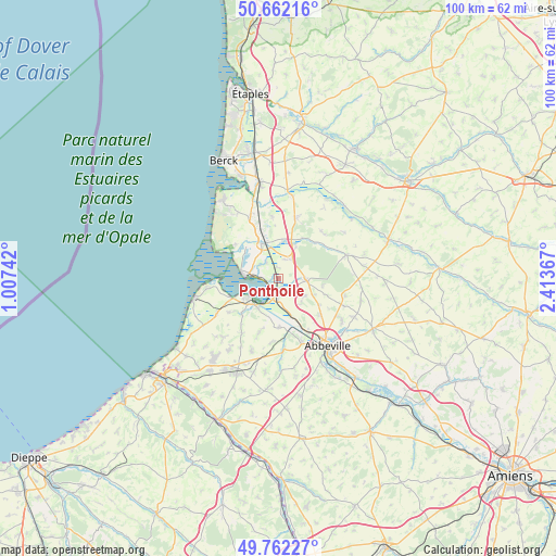
Ponthoile GPS coordinates[2]
50° 12' 51.624" North, 1° 42' 37.98" East
| Map corner | latitude | longitude |
|---|---|---|
| Upper-left | 50.66216°, | 1.00742° |
| Center: | 50.21434°, | 1.71055° |
| Lower-right: | 49.76227°, | 2.41367° |
| Map W x H: | 100.1×100.1 km | = 62.2×62.2mi |
| max Lat: | 51.07786° ⇑5.1% North |
| Ponthoile: | 50.21434° |
| min Lat: | ⇓94.9% South 41.3874° |
| min Long | Ponthoile | max Long |
| -5.08615° | 1.71055° | 9.52242° |
| W 39.7%⇐ | ⇒60.3% E |
Elevation
Elevation of Ponthoile is 7 m = 23 ft, and this is 186.7 m = 613 ft below average elevation for this country.
| Max E: |
2333 m = 7654 ft | 98.6% |
| Avg. | 193.7 m = 635 ft | |
| Ponthoile | 7 m = 23 ft | |
Min E: |
-1 m = -3 ft | 1.4% |
See also: France elevation on elevation.city.
Geographical zone
Ponthoile is located in North temperate zone (between Tropic of Cancer and the Arctic Circle). Distance of this North polar circle is 1817.9 km =1129.6 mi to North.| Distance of | km | miles | from Ponthoile |
|---|---|---|---|
| North Pole | 4423.8 | 2748.8 | to North |
| Arctic Circle | 1817.9 | 1129.6 | to North |
| Tropic Cancer | 2977.4 | 1850.1 | to South |
| Equator | 5583.3 | 3469.3 | to South |


Nearby cities:
15 places around Ponthoile: (largest is in red/bold)
• Arrest
11.5 km =7.1 mi,  216°
216°
• Boismont
7.2 km =4.5 mi,  194°
194°
• Buigny-Saint-Maclou
9.8 km =6.1 mi,  131°
131°
• Cambron
12.3 km =7.6 mi,  159°
159°
• Lanchères
12.7 km =7.9 mi,  240°
240°
• Le Crotoy
6.1 km =3.8 mi,  271°
271°
• Nouvion
5.4 km =3.4 mi,  107°
107°
• Noyelles-sur-Mer
3.2 km =2 mi,  184°
184°
• Pendé
10.7 km =6.6 mi, 236°
• Quend
12.5 km =7.8 mi,  334°
334°
• Quesnoy-le-Montant
11.6 km =7.2 mi, 187°
• Rue
6.9 km =4.3 mi,  336°
336°
• Sailly-Flibeaucourt
5.5 km =3.4 mi, 127°
• Saint-Valery-sur-Somme
6.5 km =4 mi, 237°
• Vron
11.7 km =7.3 mi,  15°
15°
Sources, notices
• [Note1] Compared only with cities in France existing in our database
• [Src1] Map data: © OpenStreetMap contributors (CC-BY-SA)
• [Src2] Other city data from geonames.org with taken over terms of usage.
• [Src3] Geographical zone / Annual Mean Temperature by Robert A. Rohde @ Wikipedia
