Rue geodata
Rue (Hauts-de-France) is a populated place; located in France in Europe/Paris (GMT+2) time zone. With population of 3,235 people, there are 3020 cities with bigger population in this country. Compared to other cities in France, 95.3% of cities are located further ↓South; 60.7% of cities are located further →East and 98.2% of cities have higher elevation than Rue. Note1


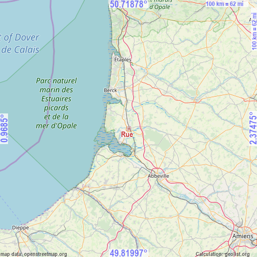
Rue GPS coordinates[2]
50° 16' 17.4" North, 1° 40' 17.868" East
| Map corner | latitude | longitude |
|---|---|---|
| Upper-left | 50.71878°, | 0.9685° |
| Center: | 50.2715°, | 1.67163° |
| Lower-right: | 49.81997°, | 2.37475° |
| Map W x H: | 99.9×99.9 km | = 62.1×62.1mi |
| max Lat: | 51.07786° ⇑4.7% North |
| Rue: | 50.2715° |
| min Lat: | ⇓95.3% South 41.3874° |
| min Long | Rue | max Long |
| -5.08615° | 1.67163° | 9.52242° |
| W 39.3%⇐ | ⇒60.7% E |
Elevation
Elevation of Rue is 8 m = 26 ft, and this is 185.7 m = 609 ft below average elevation for this country.
| Max E: |
2333 m = 7654 ft | 98.2% |
| Avg. | 193.7 m = 635 ft | |
| Rue | 8 m = 26 ft | |
Min E: |
-1 m = -3 ft | 1.8% |
See also: France elevation on elevation.city.
Geographical zone
Rue is located in North temperate zone (between Tropic of Cancer and the Arctic Circle). Distance of this North polar circle is 1811.5 km =1125.6 mi to North.| Distance of | km | miles | from Rue |
|---|---|---|---|
| North Pole | 4417.4 | 2744.8 | to North |
| Arctic Circle | 1811.5 | 1125.6 | to North |
| Tropic Cancer | 2983.7 | 1854 | to South |
| Equator | 5589.7 | 3473.3 | to South |


Nearby cities:
15 places around Rue: (largest is in red/bold)
• Boismont
13.3 km =8.3 mi,  175°
175°
• Conchil-le-Temple
10.9 km =6.8 mi,  357°
357°
• Crécy-en-Ponthieu
15 km =9.3 mi,  98°
98°
• Fort-Mahon-Plage
11 km =6.8 mi,  313°
313°
• Groffliers
13.2 km =8.2 mi,  342°
342°
• Le Crotoy
7 km =4.3 mi,  208°
208°
• Nouvion
11.2 km =7 mi,  135°
135°
• Noyelles-sur-Mer
9.9 km =6.2 mi,  165°
165°
• Pendé
13.8 km =8.6 mi, 206°
• Ponthoile
6.9 km =4.3 mi,  156°
156°
• Quend
5.5 km =3.4 mi,  332°
332°
• Sailly-Flibeaucourt
12 km =7.5 mi, 143°
• Saint-Valery-sur-Somme
10.2 km =6.3 mi,  195°
195°
• Verton
14.6 km =9.1 mi,  353°
353°
• Vron
7.7 km =4.8 mi,  50°
50°
Sources, notices
• [Note1] Compared only with cities in France existing in our database
• [Src1] Map data: © OpenStreetMap contributors (CC-BY-SA)
• [Src2] Other city data from geonames.org with taken over terms of usage.
• [Src3] Geographical zone / Annual Mean Temperature by Robert A. Rohde @ Wikipedia
