Vouzan geodata
Vouzan (Nouvelle-Aquitaine) is a populated place; located in France in Europe/Paris (GMT+2) time zone. With population of 706 people, there are 11718 cities with bigger population in this country. Compared to other cities in France, 72.6% of cities are located further ↑North; 74.8% of cities are located further →East and 50.6% of cities have lower elevation than Vouzan. Note1
Administrative division(s):
- Level 1: Nouvelle-Aquitaine
- Level 2: Charente
- Level 3: Arrondissement d’Angoulême
- Level 4: Vouzan


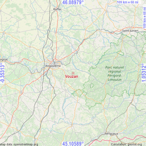
Vouzan GPS coordinates[2]
45° 36' 0" North, 0° 21' 0" East
| Map corner | latitude | longitude |
|---|---|---|
| Upper-left | 46.08979°, | -0.35313° |
| Center: | 45.6°, | 0.35° |
| Lower-right: | 45.10589°, | 1.05312° |
| Map W x H: | 109.4×109.4 km | = 68×68mi |
| max Lat: | 51.07786° ⇑72.6% North |
| Vouzan: | 45.6° |
| min Lat: | ⇓27.4% South 41.3874° |
| min Long | Vouzan | max Long |
| -5.08615° | 0.35° | 9.52242° |
| W 25.2%⇐ | ⇒74.8% E |
Elevation
Elevation of Vouzan is 134 m = 440 ft, and this is 59.7 m = 196 ft below average elevation for this country.
| Max E: |
2333 m = 7654 ft | 49.4% |
| Avg. | 193.7 m = 635 ft | |
| Vouzan | 134 m = 440 ft | |
Min E: |
-1 m = -3 ft | 50.6% |
See also: France elevation on elevation.city.
Geographical zone
Vouzan is located in North temperate zone (between Tropic of Cancer and the Arctic Circle). Distance of this North polar circle is 2330.9 km =1448.4 mi to North.| Distance of | km | miles | from Vouzan |
|---|---|---|---|
| North Pole | 4936.8 | 3067.6 | to North |
| Arctic Circle | 2330.9 | 1448.4 | to North |
| Tropic Cancer | 2464.3 | 1531.2 | to South |
| Equator | 5070.2 | 3150.5 | to South |


Nearby cities:
15 places around Vouzan: (largest is in red/bold)
• Bouëx
3.2 km =2 mi,  305°
305°
• Chazelles
5.4 km =3.4 mi,  14°
14°
• Dignac
7.6 km =4.7 mi,  223°
223°
• Dirac
7.8 km =4.8 mi,  270°
270°
• Garat
7.5 km =4.7 mi,  299°
299°
• Magnac-sur-Touvre
11.7 km =7.3 mi, 309°
• Marthon
7.4 km =4.6 mi,  77°
77°
• Mornac
11.3 km =7 mi,  325°
325°
• Pranzac
7.4 km =4.6 mi,  0°
0°
• Rougnac
7.4 km =4.6 mi,  180°
180°
• Saint-Sornin
12.4 km =7.7 mi,  33°
33°
• Sers
2.6 km =1.6 mi, 270°
• Soyaux
12.9 km =8 mi, 295°
• Torsac
11 km =6.8 mi,  250°
250°
• Touvre
10.7 km =6.6 mi, 313°
Sources, notices
• [Note1] Compared only with cities in France existing in our database
• [Src1] Map data: © OpenStreetMap contributors (CC-BY-SA)
• [Src2] Other city data from geonames.org with taken over terms of usage.
• [Src3] Geographical zone / Annual Mean Temperature by Robert A. Rohde @ Wikipedia
