Volesvres geodata
Volesvres (Bourgogne-Franche-Comté) is a populated place; located in France in Europe/Paris (GMT+2) time zone. With population of 574 people, there are 13763 cities with bigger population in this country. Compared to other cities in France, 60.3% of cities are located further ↑North; 69.3% of cities are located further ←West and 77.8% of cities have lower elevation than Volesvres. Note1
Administrative division(s):
- Level 1: Bourgogne-Franche-Comté
- Level 2: Département de Saône-et-Loire
- Level 3: Arrondissement de Charolles
- Level 4: Volesvres


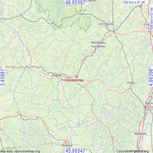
Volesvres GPS coordinates[2]
46° 28' 18.732" North, 4° 9' 35.748" East
| Map corner | latitude | longitude |
|---|---|---|
| Upper-left | 46.95397°, | 3.45681° |
| Center: | 46.47187°, | 4.15993° |
| Lower-right: | 45.98547°, | 4.86306° |
| Map W x H: | 107.7×107.7 km | = 66.9×66.9mi |
| max Lat: | 51.07786° ⇑60.3% North |
| Volesvres: | 46.47187° |
| min Lat: | ⇓39.7% South 41.3874° |
| min Long | Volesvres | max Long |
| -5.08615° | 4.15993° | 9.52242° |
| W 69.3%⇐ | ⇒30.7% E |
Elevation
Elevation of Volesvres is 270 m = 886 ft, and this is 76.3 m = 250 ft above average elevation for this country.
| Max E: |
2333 m = 7654 ft | 22.2% |
| Volesvres | 270 m 886 ft | |
| Avg. | 193.7 m = 635 ft | |
Min E: |
-1 m = -3 ft | 77.8% |
See also: France elevation on elevation.city.
Geographical zone
Volesvres is located in North temperate zone (between Tropic of Cancer and the Arctic Circle). Distance of this North polar circle is 2234 km =1388.1 mi to North.| Distance of | km | miles | from Volesvres |
|---|---|---|---|
| North Pole | 4839.9 | 3007.4 | to North |
| Arctic Circle | 2234 | 1388.1 | to North |
| Tropic Cancer | 2561.3 | 1591.5 | to South |
| Equator | 5167.2 | 3210.7 | to South |


Nearby cities:
15 places around Volesvres: (largest is in red/bold)
• Charolles
9.8 km =6.1 mi,  115°
115°
• Chassenard
14.3 km =8.9 mi,  254°
254°
• Digoin
13.9 km =8.6 mi,  274°
274°
• Gueugnon
16.4 km =10.2 mi,  333°
333°
• Génelard
13.5 km =8.4 mi,  25°
25°
• La Motte-Saint-Jean
15.2 km =9.4 mi,  280°
280°
• Molinet
17.2 km =10.7 mi, 267°
• Palinges
10.2 km =6.3 mi, 26°
• Paray-le-Monial
3.9 km =2.4 mi,  240°
240°
• Perrecy-les-Forges
16.4 km =10.2 mi,  14°
14°
• Poisson
10 km =6.2 mi,  193°
193°
• Rigny-sur-Arroux
12.2 km =7.6 mi,  303°
303°
• Saint-Julien-de-Civry
12.9 km =8 mi,  155°
155°
• Saint-Yan
11.5 km =7.1 mi,  234°
234°
• Vendenesse-lès-Charolles
14 km =8.7 mi,  103°
103°
Sources, notices
• [Note1] Compared only with cities in France existing in our database
• [Src1] Map data: © OpenStreetMap contributors (CC-BY-SA)
• [Src2] Other city data from geonames.org with taken over terms of usage.
• [Src3] Geographical zone / Annual Mean Temperature by Robert A. Rohde @ Wikipedia
