Rigny-sur-Arroux geodata
Rigny-sur-Arroux (Bourgogne-Franche-Comté) is a populated place; located in France in Europe/Paris (GMT+2) time zone. With population of 621 people, there are 12967 cities with bigger population in this country. Compared to other cities in France, 59.9% of cities are located further ↑North; 68.1% of cities are located further ←West and 72.8% of cities have lower elevation than Rigny-sur-Arroux. Note1
Administrative division(s):
- Level 1: Bourgogne-Franche-Comté
- Level 2: Département de Saône-et-Loire
- Level 3: Arrondissement de Charolles
- Level 4: Rigny-sur-Arroux


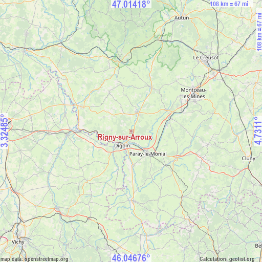
Rigny-sur-Arroux GPS coordinates[2]
46° 31' 57.432" North, 4° 1' 40.692" East
| Map corner | latitude | longitude |
|---|---|---|
| Upper-left | 47.01418°, | 3.32485° |
| Center: | 46.53262°, | 4.02797° |
| Lower-right: | 46.04676°, | 4.7311° |
| Map W x H: | 107.6×107.6 km | = 66.9×66.9mi |
| max Lat: | 51.07786° ⇑59.9% North |
| Rigny-sur-Arroux: | 46.53262° |
| min Lat: | ⇓40.1% South 41.3874° |
| min Long | Rigny-sur-Arrou | max Long |
| -5.08615° | 4.02797° | 9.52242° |
| W 68.1%⇐ | ⇒31.9% E |
Elevation
Elevation of Rigny-sur-Arroux is 235 m = 771 ft, and this is 41.3 m = 135 ft above average elevation for this country.
| Max E: |
2333 m = 7654 ft | 27.2% |
| Rigny-sur-Arroux | 235 m 771 ft | |
| Avg. | 193.7 m = 635 ft | |
Min E: |
-1 m = -3 ft | 72.8% |
See also: France elevation on elevation.city.
Geographical zone
Rigny-sur-Arroux is located in North temperate zone (between Tropic of Cancer and the Arctic Circle). Distance of this North polar circle is 2227.2 km =1383.9 mi to North.| Distance of | km | miles | from Rigny-sur-Arroux |
|---|---|---|---|
| North Pole | 4833.1 | 3003.1 | to North |
| Arctic Circle | 2227.2 | 1383.9 | to North |
| Tropic Cancer | 2568 | 1595.7 | to South |
| Equator | 5173.9 | 3214.9 | to South |


Nearby cities:
15 places around Rigny-sur-Arroux: (largest is in red/bold)
• Chalmoux
15.6 km =9.7 mi,  298°
298°
• Chassenard
11.1 km =6.9 mi,  199°
199°
• Digoin
6.8 km =4.2 mi,  213°
213°
• Gueugnon
8.3 km =5.2 mi,  18°
18°
• La Motte-Saint-Jean
6.4 km =4 mi,  230°
230°
• Molinet
10.2 km =6.3 mi,  223°
223°
• Neuvy-Grandchamp
9.5 km =5.9 mi,  311°
311°
• Palinges
14.8 km =9.2 mi,  80°
80°
• Paray-le-Monial
11 km =6.8 mi,  142°
142°
• Saint-Agnan
12.9 km =8 mi,  253°
253°
• Saint-François
16.1 km =10 mi, 215°
• Saint-Yan
13.5 km =8.4 mi,  176°
176°
• Uxeau
14.5 km =9 mi,  358°
358°
• Vendenesse-sur-Arroux
10.9 km =6.8 mi,  14°
14°
• Volesvres
12.2 km =7.6 mi,  123°
123°
Sources, notices
• [Note1] Compared only with cities in France existing in our database
• [Src1] Map data: © OpenStreetMap contributors (CC-BY-SA)
• [Src2] Other city data from geonames.org with taken over terms of usage.
• [Src3] Geographical zone / Annual Mean Temperature by Robert A. Rohde @ Wikipedia
