Vœgtlinshoffen geodata
Vœgtlinshoffen (Grand Est) is a populated place; located in France in Europe/Paris (GMT+2) time zone. With population of 501 people, there are 15224 cities with bigger population in this country. Compared to other cities in France, 59.6% of cities are located further ↓South; 96.3% of cities are located further ←West and 84.2% of cities have lower elevation than Vœgtlinshoffen. Note1
Administrative division(s):
- Level 1: Grand Est
- Level 2: Haut-Rhin
- Level 3: Arrondissement de Colmar-Ribeauvillé
- Level 4: Vœgtlinshoffen


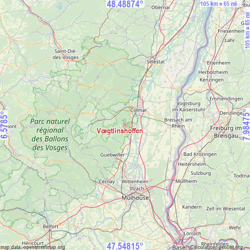
Vœgtlinshoffen GPS coordinates[2]
48° 1' 14.124" North, 7° 16' 53.832" East
| Map corner | latitude | longitude |
|---|---|---|
| Upper-left | 48.48874°, | 6.5785° |
| Center: | 48.02059°, | 7.28162° |
| Lower-right: | 47.54815°, | 7.98475° |
| Map W x H: | 104.6×104.6 km | = 65×65mi |
| max Lat: | 51.07786° ⇑40.4% North |
| Vœgtlinshoffen: | 48.02059° |
| min Lat: | ⇓59.6% South 41.3874° |
| min Long | Vœgtlinshoffen | max Long |
| -5.08615° | 7.28162° | 9.52242° |
| W 96.3%⇐ | ⇒3.7% E |
Elevation
Elevation of Vœgtlinshoffen is 337 m = 1106 ft, and this is 143.3 m = 470 ft above average elevation for this country.
| Max E: |
2333 m = 7654 ft | 15.8% |
| Vœgtlinshoffen | 337 m 1106 ft | |
| Avg. | 193.7 m = 635 ft | |
Min E: |
-1 m = -3 ft | 84.2% |
See also: France elevation on elevation.city.
Geographical zone
Vœgtlinshoffen is located in North temperate zone (between Tropic of Cancer and the Arctic Circle). Distance of this North polar circle is 2061.8 km =1281.1 mi to North.| Distance of | km | miles | from Vœgtlinshoffen |
|---|---|---|---|
| North Pole | 4667.7 | 2900.4 | to North |
| Arctic Circle | 2061.8 | 1281.1 | to North |
| Tropic Cancer | 2733.5 | 1698.5 | to South |
| Equator | 5339.4 | 3317.7 | to South |


Nearby cities:
15 places around Vœgtlinshoffen: (largest is in red/bold)
• Eguisheim
3.1 km =1.9 mi,  36°
36°
• Gueberschwihr
1.9 km =1.2 mi,  193°
193°
• Hattstatt
1.8 km =1.1 mi,  125°
125°
• Herrlisheim-près-Colmar
3.4 km =2.1 mi,  94°
94°
• Osenbach
6.1 km =3.8 mi,  230°
230°
• Pfaffenheim
3.9 km =2.4 mi,  171°
171°
• Rouffach
7.1 km =4.4 mi, 168°
• Soultzbach-les-Bains
6 km =3.7 mi,  288°
288°
• Soultzmatt
7.3 km =4.5 mi,  206°
206°
• Walbach
6.4 km =4 mi,  317°
317°
• Westhalten
7.2 km =4.5 mi, 192°
• Wettolsheim
4.3 km =2.7 mi,  16°
16°
• Wihr-au-Val
6.7 km =4.2 mi,  301°
301°
• Wintzenheim
5.8 km =3.6 mi,  6°
6°
• Zimmerbach
6.8 km =4.2 mi,  329°
329°
Sources, notices
• [Note1] Compared only with cities in France existing in our database
• [Src1] Map data: © OpenStreetMap contributors (CC-BY-SA)
• [Src2] Other city data from geonames.org with taken over terms of usage.
• [Src3] Geographical zone / Annual Mean Temperature by Robert A. Rohde @ Wikipedia
