Hattstatt geodata
Hattstatt (Grand Est) is a populated place; located in France in Europe/Paris (GMT+2) time zone. With population of 822 people, there are 10372 cities with bigger population in this country. Compared to other cities in France, 59.4% of cities are located further ↓South; 96.5% of cities are located further ←West and 67.2% of cities have lower elevation than Hattstatt. Note1
Administrative division(s):
- Level 1: Grand Est
- Level 2: Haut-Rhin
- Level 3: Arrondissement de Thann-Guebwiller
- Level 4: Hattstatt


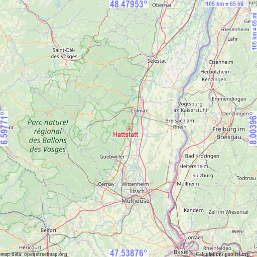
Hattstatt GPS coordinates[2]
48° 0' 40.644" North, 7° 18' 3.024" East
| Map corner | latitude | longitude |
|---|---|---|
| Upper-left | 48.47953°, | 6.59771° |
| Center: | 48.01129°, | 7.30084° |
| Lower-right: | 47.53876°, | 8.00396° |
| Map W x H: | 104.6×104.6 km | = 65×65mi |
| max Lat: | 51.07786° ⇑40.6% North |
| Hattstatt: | 48.01129° |
| min Lat: | ⇓59.4% South 41.3874° |
| min Long | Hattstatt | max Long |
| -5.08615° | 7.30084° | 9.52242° |
| W 96.5%⇐ | ⇒3.5% E |
Elevation
Elevation of Hattstatt is 205 m = 673 ft, and this is 11.3 m = 37 ft above average elevation for this country.
| Max E: |
2333 m = 7654 ft | 32.8% |
| Hattstatt | 205 m 673 ft | |
| Avg. | 193.7 m = 635 ft | |
Min E: |
-1 m = -3 ft | 67.2% |
See also: France elevation on elevation.city.
Geographical zone
Hattstatt is located in North temperate zone (between Tropic of Cancer and the Arctic Circle). Distance of this North polar circle is 2062.8 km =1281.8 mi to North.| Distance of | km | miles | from Hattstatt |
|---|---|---|---|
| North Pole | 4668.7 | 2901 | to North |
| Arctic Circle | 2062.8 | 1281.8 | to North |
| Tropic Cancer | 2732.4 | 1697.8 | to South |
| Equator | 5338.4 | 3317.1 | to South |


Nearby cities:
15 places around Hattstatt: (largest is in red/bold)
• Eguisheim
3.5 km =2.2 mi,  6°
6°
• Gueberschwihr
2.1 km =1.3 mi,  246°
246°
• Herrlisheim-près-Colmar
2.1 km =1.3 mi,  67°
67°
• Logelheim
8 km =5 mi,  82°
82°
• Niederhergheim
7.7 km =4.8 mi,  111°
111°
• Osenbach
6.8 km =4.2 mi, 245°
• Pfaffenheim
3 km =1.9 mi,  196°
196°
• Rouffach
5.9 km =3.7 mi,  180°
180°
• Sainte-Croix-en-Plaine
6.3 km =3.9 mi,  92°
92°
• Soultzbach-les-Bains
7.7 km =4.8 mi,  292°
292°
• Soultzmatt
7.2 km =4.5 mi,  220°
220°
• Vœgtlinshoffen
1.8 km =1.1 mi,  305°
305°
• Westhalten
6.7 km =4.2 mi,  206°
206°
• Wettolsheim
5.1 km =3.2 mi,  358°
358°
• Wintzenheim
6.9 km =4.3 mi,  353°
353°
Sources, notices
• [Note1] Compared only with cities in France existing in our database
• [Src1] Map data: © OpenStreetMap contributors (CC-BY-SA)
• [Src2] Other city data from geonames.org with taken over terms of usage.
• [Src3] Geographical zone / Annual Mean Temperature by Robert A. Rohde @ Wikipedia
