Viols-le-Fort geodata
Viols-le-Fort (Occitanie) is a populated place; located in France in Europe/Paris (GMT+2) time zone. With population of 957 people, there are 9150 cities with bigger population in this country. Compared to other cities in France, 89.8% of cities are located further ↑North; 65.8% of cities are located further ←West and 76.9% of cities have lower elevation than Viols-le-Fort. Note1
Administrative division(s):
- Level 1: Occitanie
- Level 2: Département de l'Hérault
- Level 3: Arrondissement de Lodève
- Level 4: Viols-le-Fort


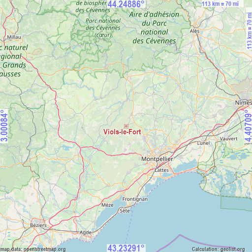
Viols-le-Fort GPS coordinates[2]
43° 44' 34.944" North, 3° 42' 14.256" East
| Map corner | latitude | longitude |
|---|---|---|
| Upper-left | 44.24886°, | 3.00084° |
| Center: | 43.74304°, | 3.70396° |
| Lower-right: | 43.23291°, | 4.40709° |
| Map W x H: | 113×113 km | = 70.2×70.2mi |
| max Lat: | 51.07786° ⇑89.8% North |
| Viols-le-Fort: | 43.74304° |
| min Lat: | ⇓10.2% South 41.3874° |
| min Long | Viols-le-Fort | max Long |
| -5.08615° | 3.70396° | 9.52242° |
| W 65.8%⇐ | ⇒34.2% E |
Elevation
Elevation of Viols-le-Fort is 263 m = 863 ft, and this is 69.3 m = 227 ft above average elevation for this country.
| Max E: |
2333 m = 7654 ft | 23.1% |
| Viols-le-Fort | 263 m 863 ft | |
| Avg. | 193.7 m = 635 ft | |
Min E: |
-1 m = -3 ft | 76.9% |
See also: France elevation on elevation.city.
Geographical zone
Viols-le-Fort is located in North temperate zone (between Tropic of Cancer and the Arctic Circle). Distance of this Northern Tropic circle is 2257.9 km =1403 mi to South.| Distance of | km | miles | from Viols-le-Fort |
|---|---|---|---|
| North Pole | 5143.3 | 3195.9 | to North |
| Arctic Circle | 2537.4 | 1576.7 | to North |
| Tropic Cancer | 2257.9 | 1403 | to South |
| Equator | 4863.8 | 3022.2 | to South |


Nearby cities:
15 places around Viols-le-Fort: (largest is in red/bold)
• Aniane
11.4 km =7.1 mi,  235°
235°
• Argelliers
5.5 km =3.4 mi,  207°
207°
• Combaillaux
9.4 km =5.8 mi,  147°
147°
• Grabels
13 km =8.1 mi,  144°
144°
• Les Matelles
8.9 km =5.5 mi,  100°
100°
• Montarnaud
10.6 km =6.6 mi,  183°
183°
• Prades-le-Lez
13.9 km =8.6 mi,  111°
111°
• Saint-Clément-de-Rivière
12.3 km =7.6 mi,  122°
122°
• Saint-Gély-du-Fesc
9.9 km =6.2 mi, 124°
• Saint-Jean-de-Fos
13.1 km =8.1 mi,  249°
249°
• Saint-Martin-de-Londres
5.7 km =3.5 mi,  22°
22°
• Saint-Mathieu-de-Tréviers
12.7 km =7.9 mi,  77°
77°
• Saint-Paul-et-Valmalle
13.1 km =8.1 mi,  190°
190°
• Saint-Vincent-de-Barbeyrargues
14.6 km =9.1 mi, 106°
• Vailhauquès
8.1 km =5 mi,  170°
170°
Sources, notices
• [Note1] Compared only with cities in France existing in our database
• [Src1] Map data: © OpenStreetMap contributors (CC-BY-SA)
• [Src2] Other city data from geonames.org with taken over terms of usage.
• [Src3] Geographical zone / Annual Mean Temperature by Robert A. Rohde @ Wikipedia
