Saint-Paul-et-Valmalle geodata
Saint-Paul-et-Valmalle (Occitanie) is a populated place; located in France in Europe/Paris (GMT+2) time zone. With population of 846 people, there are 10125 cities with bigger population in this country. Compared to other cities in France, 91.5% of cities are located further ↑North; 65.6% of cities are located further ←West and 57.4% of cities have lower elevation than Saint-Paul-et-Valmalle. Note1
Administrative division(s):
- Level 1: Occitanie
- Level 2: Département de l'Hérault
- Level 3: Arrondissement de Lodève
- Level 4: Saint-Paul-et-Valmalle


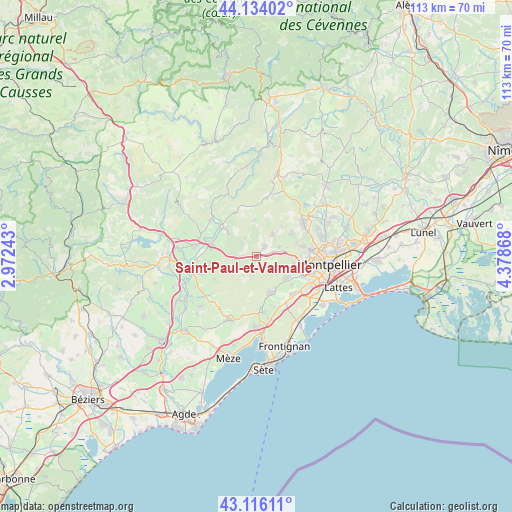
Saint-Paul-et-Valmalle GPS coordinates[2]
43° 37' 37.992" North, 3° 40' 32.016" East
| Map corner | latitude | longitude |
|---|---|---|
| Upper-left | 44.13402°, | 2.97243° |
| Center: | 43.62722°, | 3.67556° |
| Lower-right: | 43.11611°, | 4.37868° |
| Map W x H: | 113.2×113.2 km | = 70.3×70.3mi |
| max Lat: | 51.07786° ⇑91.5% North |
| Saint-Paul-et-Valmalle: | 43.62722° |
| min Lat: | ⇓8.5% South 41.3874° |
| min Long | Saint-Paul-et-V | max Long |
| -5.08615° | 3.67556° | 9.52242° |
| W 65.6%⇐ | ⇒34.4% E |
Elevation
Elevation of Saint-Paul-et-Valmalle is 159 m = 522 ft, and this is 34.7 m = 114 ft below average elevation for this country.
| Max E: |
2333 m = 7654 ft | 42.6% |
| Avg. | 193.7 m = 635 ft | |
| Saint-Paul-et-Valmalle | 159 m = 522 ft | |
Min E: |
-1 m = -3 ft | 57.4% |
See also: France elevation on elevation.city.
Geographical zone
Saint-Paul-et-Valmalle is located in North temperate zone (between Tropic of Cancer and the Arctic Circle). Distance of this Northern Tropic circle is 2245 km =1395 mi to South.| Distance of | km | miles | from Saint-Paul-et-Valmalle |
|---|---|---|---|
| North Pole | 5156.2 | 3203.9 | to North |
| Arctic Circle | 2550.3 | 1584.7 | to North |
| Tropic Cancer | 2245 | 1395 | to South |
| Equator | 4850.9 | 3014.2 | to South |


Nearby cities:
15 places around Saint-Paul-et-Valmalle: (largest is in red/bold)
• Aniane
9.5 km =5.9 mi,  311°
311°
• Argelliers
8 km =5 mi,  357°
357°
• Combaillaux
8.9 km =5.5 mi,  56°
56°
• Cournonsec
9 km =5.6 mi,  164°
164°
• Cournonterral
8.4 km =5.2 mi,  154°
154°
• Gignac
10.4 km =6.5 mi,  285°
285°
• Grabels
10.2 km =6.3 mi,  76°
76°
• Juvignac
11 km =6.8 mi,  97°
97°
• Montarnaud
2.8 km =1.7 mi,  37°
37°
• Murviel-lès-Montpellier
5.6 km =3.5 mi,  116°
116°
• Pignan
8.3 km =5.2 mi,  125°
125°
• Saint-Bauzille-de-la-Sylve
10.6 km =6.6 mi,  263°
263°
• Saussan
10.1 km =6.3 mi, 127°
• Vailhauquès
6.1 km =3.8 mi, 36°
• Vendémian
10.5 km =6.5 mi,  240°
240°
Sources, notices
• [Note1] Compared only with cities in France existing in our database
• [Src1] Map data: © OpenStreetMap contributors (CC-BY-SA)
• [Src2] Other city data from geonames.org with taken over terms of usage.
• [Src3] Geographical zone / Annual Mean Temperature by Robert A. Rohde @ Wikipedia
