Saint-Clément-de-Rivière geodata
Saint-Clément-de-Rivière (Occitanie) is a populated place; located in France in Europe/Paris (GMT+2) time zone. With population of 5,216 people, there are 1887 cities with bigger population in this country. Compared to other cities in France, 90.7% of cities are located further ↑North; 66.5% of cities are located further ←West and 64.9% of cities have higher elevation than Saint-Clément-de-Rivière. Note1
Administrative division(s):
- Level 1: Occitanie
- Level 2: Département de l'Hérault
- Level 3: Arrondissement de Lodève
- Level 4: Saint-Clément-de-Rivière
Current local time in Saint-Clément-de-Rivière:
04:41 AM, WednesdayDifference from your time zone: hours


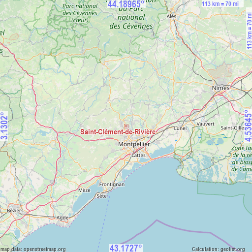
Saint-Clément-de-Rivière GPS coordinates[2]
43° 40' 59.988" North, 3° 49' 59.988" East
| Map corner | latitude | longitude |
|---|---|---|
| Upper-left | 44.18965°, | 3.1302° |
| Center: | 43.68333°, | 3.83333° |
| Lower-right: | 43.1727°, | 4.53645° |
| Map W x H: | 113.1×113.1 km | = 70.3×70.3mi |
| max Lat: | 51.07786° ⇑90.7% North |
| Saint-Clément-de-Rivière: | 43.68333° |
| min Lat: | ⇓9.3% South 41.3874° |
| min Long | Saint-Clément- | max Long |
| -5.08615° | 3.83333° | 9.52242° |
| W 66.5%⇐ | ⇒33.5% E |
Elevation
Elevation of Saint-Clément-de-Rivière is 90 m = 295 ft, and this is 103.7 m = 340 ft below average elevation for this country.
| Max E: |
2333 m = 7654 ft | 64.9% |
| Avg. | 193.7 m = 635 ft | |
| Saint-Clément-de-Rivière | 90 m = 295 ft | |
Min E: |
-1 m = -3 ft | 35.1% |
See also: France elevation on elevation.city.
Geographical zone
Saint-Clément-de-Rivière is located in North temperate zone (between Tropic of Cancer and the Arctic Circle). Distance of this Northern Tropic circle is 2251.2 km =1398.8 mi to South.| Distance of | km | miles | from Saint-Clément-de-Rivière |
|---|---|---|---|
| North Pole | 5149.9 | 3200 | to North |
| Arctic Circle | 2544 | 1580.8 | to North |
| Tropic Cancer | 2251.2 | 1398.8 | to South |
| Equator | 4857.1 | 3018.1 | to South |


Nearby cities:
15 places around Saint-Clément-de-Rivière: (largest is in red/bold)
• Assas
5.8 km =3.6 mi,  68°
68°
• Castelnau-le-Lez
7.7 km =4.8 mi,  136°
136°
• Clapiers
5.3 km =3.3 mi,  121°
121°
• Combaillaux
5.4 km =3.4 mi,  256°
256°
• Grabels
4.8 km =3 mi,  215°
215°
• Jacou
6.8 km =4.2 mi,  111°
111°
• Juvignac
7.9 km =4.9 mi,  193°
193°
• Les Matelles
5.3 km =3.3 mi,  342°
342°
• Montferrier-sur-Lez
2.4 km =1.5 mi, 136°
• Montpellier
8.8 km =5.5 mi,  156°
156°
• Prades-le-Lez
3 km =1.9 mi,  57°
57°
• Saint-Gély-du-Fesc
2.5 km =1.6 mi,  294°
294°
• Saint-Vincent-de-Barbeyrargues
4.5 km =2.8 mi,  53°
53°
• Teyran
7.7 km =4.8 mi,  88°
88°
• Vailhauquès
9.2 km =5.7 mi, 261°
Sources, notices
• [Note1] Compared only with cities in France existing in our database
• [Src1] Map data: © OpenStreetMap contributors (CC-BY-SA)
• [Src2] Other city data from geonames.org with taken over terms of usage.
• [Src3] Geographical zone / Annual Mean Temperature by Robert A. Rohde @ Wikipedia
