Montarnaud geodata
Montarnaud (Occitanie) is a populated place; located in France in Europe/Paris (GMT+2) time zone. With population of 2,627 people, there are 3712 cities with bigger population in this country. Compared to other cities in France, 91.3% of cities are located further ↑North; 65.7% of cities are located further ←West and 52.3% of cities have higher elevation than Montarnaud. Note1
Administrative division(s):
- Level 1: Occitanie
- Level 2: Département de l'Hérault
- Level 3: Arrondissement de Lodève
- Level 4: Montarnaud


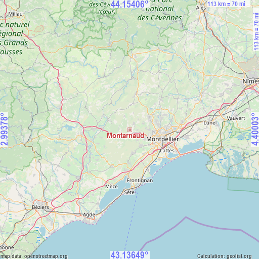
Montarnaud GPS coordinates[2]
43° 38' 50.748" North, 3° 41' 48.84" East
| Map corner | latitude | longitude |
|---|---|---|
| Upper-left | 44.15406°, | 2.99378° |
| Center: | 43.64743°, | 3.6969° |
| Lower-right: | 43.13649°, | 4.40003° |
| Map W x H: | 113.1×113.1 km | = 70.3×70.3mi |
| max Lat: | 51.07786° ⇑91.3% North |
| Montarnaud: | 43.64743° |
| min Lat: | ⇓8.7% South 41.3874° |
| min Long | Montarnaud | max Long |
| -5.08615° | 3.6969° | 9.52242° |
| W 65.7%⇐ | ⇒34.3% E |
Elevation
Elevation of Montarnaud is 124 m = 407 ft, and this is 69.7 m = 229 ft below average elevation for this country.
| Max E: |
2333 m = 7654 ft | 52.3% |
| Avg. | 193.7 m = 635 ft | |
| Montarnaud | 124 m = 407 ft | |
Min E: |
-1 m = -3 ft | 47.7% |
See also: France elevation on elevation.city.
Geographical zone
Montarnaud is located in North temperate zone (between Tropic of Cancer and the Arctic Circle). Distance of this Northern Tropic circle is 2247.2 km =1396.3 mi to South.| Distance of | km | miles | from Montarnaud |
|---|---|---|---|
| North Pole | 5153.9 | 3202.5 | to North |
| Arctic Circle | 2548 | 1583.3 | to North |
| Tropic Cancer | 2247.2 | 1396.3 | to South |
| Equator | 4853.1 | 3015.6 | to South |


Nearby cities:
15 places around Montarnaud: (largest is in red/bold)
• Aniane
9.7 km =6 mi,  295°
295°
• Argelliers
6.1 km =3.8 mi,  340°
340°
• Combaillaux
6.3 km =3.9 mi,  64°
64°
• Cournonsec
10.9 km =6.8 mi,  176°
176°
• Cournonterral
10 km =6.2 mi,  169°
169°
• Grabels
8.2 km =5.1 mi,  89°
89°
• Juvignac
9.9 km =6.2 mi,  112°
112°
• Lavérune
11.1 km =6.9 mi,  127°
127°
• Murviel-lès-Montpellier
5.7 km =3.5 mi,  145°
145°
• Pignan
8.7 km =5.4 mi,  144°
144°
• Saint-Gély-du-Fesc
10 km =6.2 mi, 59°
• Saint-Paul-et-Valmalle
2.8 km =1.7 mi,  217°
217°
• Saussan
10.5 km =6.5 mi, 143°
• Vailhauquès
3.3 km =2.1 mi,  35°
35°
• Viols-le-Fort
10.6 km =6.6 mi,  3°
3°
Sources, notices
• [Note1] Compared only with cities in France existing in our database
• [Src1] Map data: © OpenStreetMap contributors (CC-BY-SA)
• [Src2] Other city data from geonames.org with taken over terms of usage.
• [Src3] Geographical zone / Annual Mean Temperature by Robert A. Rohde @ Wikipedia
