Villetoureix geodata
Villetoureix (Nouvelle-Aquitaine) is a populated place; located in France in Europe/Paris (GMT+2) time zone. With population of 805 people, there are 10549 cities with bigger population in this country. Compared to other cities in France, 76.7% of cities are located further ↑North; 74.7% of cities are located further →East and 70.1% of cities have higher elevation than Villetoureix. Note1
Administrative division(s):
- Level 1: Nouvelle-Aquitaine
- Level 2: Dordogne
- Level 3: Arrondissement de Périgueux
- Level 4: Villetoureix


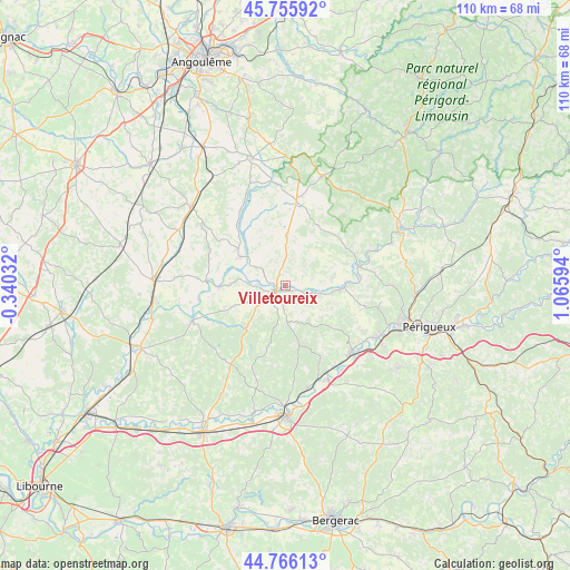
Villetoureix GPS coordinates[2]
45° 15' 47.448" North, 0° 21' 46.116" East
| Map corner | latitude | longitude |
|---|---|---|
| Upper-left | 45.75592°, | -0.34032° |
| Center: | 45.26318°, | 0.36281° |
| Lower-right: | 44.76613°, | 1.06594° |
| Map W x H: | 110.1×110.1 km | = 68.4×68.4mi |
| max Lat: | 51.07786° ⇑76.7% North |
| Villetoureix: | 45.26318° |
| min Lat: | ⇓23.3% South 41.3874° |
| min Long | Villetoureix | max Long |
| -5.08615° | 0.36281° | 9.52242° |
| W 25.3%⇐ | ⇒74.7% E |
Elevation
Elevation of Villetoureix is 78 m = 256 ft, and this is 115.7 m = 380 ft below average elevation for this country.
| Max E: |
2333 m = 7654 ft | 70.1% |
| Avg. | 193.7 m = 635 ft | |
| Villetoureix | 78 m = 256 ft | |
Min E: |
-1 m = -3 ft | 29.9% |
See also: France elevation on elevation.city.
Geographical zone
Villetoureix is located in North temperate zone (between Tropic of Cancer and the Arctic Circle). Distance of this North polar circle is 2368.4 km =1471.7 mi to North.| Distance of | km | miles | from Villetoureix |
|---|---|---|---|
| North Pole | 4974.3 | 3090.9 | to North |
| Arctic Circle | 2368.4 | 1471.7 | to North |
| Tropic Cancer | 2426.9 | 1508 | to South |
| Equator | 5032.8 | 3127.2 | to South |


Nearby cities:
15 places around Villetoureix: (largest is in red/bold)
• Allemans
5.4 km =3.4 mi,  294°
294°
• Celles
5.5 km =3.4 mi,  46°
46°
• Grand-Brassac
9.7 km =6 mi,  76°
76°
• Lisle
14.8 km =9.2 mi, 83°
• Mensignac
16.2 km =10.1 mi,  105°
105°
• Montagrier
9 km =5.6 mi, 84°
• Ribérac
2.7 km =1.7 mi,  237°
237°
• Saint-Germain-du-Salembre
15.5 km =9.6 mi,  153°
153°
• Saint-Martin-de-Ribérac
3.5 km =2.2 mi,  196°
196°
• Saint-Privat-des-Prés
11.9 km =7.4 mi,  253°
253°
• Saint-Séverin
10.6 km =6.6 mi,  303°
303°
• Saint-Vincent-de-Connezac
11.4 km =7.1 mi,  166°
166°
• Tocane-Saint-Apre
10.5 km =6.5 mi,  95°
95°
• Vanxains
8.1 km =5 mi,  230°
230°
• Verteillac
9.4 km =5.8 mi,  1°
1°
Sources, notices
• [Note1] Compared only with cities in France existing in our database
• [Src1] Map data: © OpenStreetMap contributors (CC-BY-SA)
• [Src2] Other city data from geonames.org with taken over terms of usage.
• [Src3] Geographical zone / Annual Mean Temperature by Robert A. Rohde @ Wikipedia
