Celles geodata
Celles (Nouvelle-Aquitaine) is a populated place; located in France in Europe/Paris (GMT+2) time zone. With population of 579 people, there are 13669 cities with bigger population in this country. Compared to other cities in France, 76.4% of cities are located further ↑North; 74.2% of cities are located further →East and 59.1% of cities have higher elevation than Celles. Note1
Administrative division(s):
- Level 1: Nouvelle-Aquitaine
- Level 2: Dordogne
- Level 3: Arrondissement de Périgueux
- Level 4: Celles


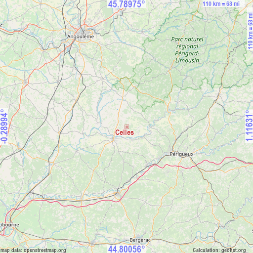
Celles GPS coordinates[2]
45° 17' 50.316" North, 0° 24' 47.448" East
| Map corner | latitude | longitude |
|---|---|---|
| Upper-left | 45.78975°, | -0.28994° |
| Center: | 45.29731°, | 0.41318° |
| Lower-right: | 44.80056°, | 1.11631° |
| Map W x H: | 110×110 km | = 68.4×68.4mi |
| max Lat: | 51.07786° ⇑76.4% North |
| Celles: | 45.29731° |
| min Lat: | ⇓23.6% South 41.3874° |
| min Long | Celles | max Long |
| -5.08615° | 0.41318° | 9.52242° |
| W 25.8%⇐ | ⇒74.2% E |
Elevation
Elevation of Celles is 105 m = 344 ft, and this is 88.7 m = 291 ft below average elevation for this country.
| Max E: |
2333 m = 7654 ft | 59.1% |
| Avg. | 193.7 m = 635 ft | |
| Celles | 105 m = 344 ft | |
Min E: |
-1 m = -3 ft | 40.9% |
See also: France elevation on elevation.city.
Geographical zone
Celles is located in North temperate zone (between Tropic of Cancer and the Arctic Circle). Distance of this North polar circle is 2364.6 km =1469.3 mi to North.| Distance of | km | miles | from Celles |
|---|---|---|---|
| North Pole | 4970.5 | 3088.5 | to North |
| Arctic Circle | 2364.6 | 1469.3 | to North |
| Tropic Cancer | 2430.7 | 1510.4 | to South |
| Equator | 5036.6 | 3129.6 | to South |


Nearby cities:
15 places around Celles: (largest is in red/bold)
• Allemans
9 km =5.6 mi,  260°
260°
• Bourdeilles
13.9 km =8.6 mi,  78°
78°
• Grand-Brassac
5.7 km =3.5 mi,  105°
105°
• Lisle
10.9 km =6.8 mi,  100°
100°
• Mensignac
14.2 km =8.8 mi,  124°
124°
• Montagrier
5.9 km =3.7 mi, 120°
• Ribérac
8.2 km =5.1 mi,  229°
229°
• Saint-Martin-de-Ribérac
8.7 km =5.4 mi,  214°
214°
• Saint-Privat-des-Prés
16.9 km =10.5 mi,  245°
245°
• Saint-Séverin
12.9 km =8 mi,  279°
279°
• Saint-Vincent-de-Connezac
14.9 km =9.3 mi,  184°
184°
• Tocane-Saint-Apre
8.1 km =5 mi,  126°
126°
• Vanxains
13.6 km =8.5 mi, 228°
• Verteillac
6.7 km =4.2 mi,  326°
326°
• Villetoureix
5.5 km =3.4 mi, 226°
Sources, notices
• [Note1] Compared only with cities in France existing in our database
• [Src1] Map data: © OpenStreetMap contributors (CC-BY-SA)
• [Src2] Other city data from geonames.org with taken over terms of usage.
• [Src3] Geographical zone / Annual Mean Temperature by Robert A. Rohde @ Wikipedia
