Verteillac geodata
Verteillac (Nouvelle-Aquitaine) is a populated place; located in France in Europe/Paris (GMT+2) time zone. With population of 708 people, there are 11684 cities with bigger population in this country. Compared to other cities in France, 75.8% of cities are located further ↑North; 74.6% of cities are located further →East and 50.5% of cities have higher elevation than Verteillac. Note1
Administrative division(s):
- Level 1: Nouvelle-Aquitaine
- Level 2: Dordogne
- Level 3: Arrondissement de Périgueux
- Level 4: Verteillac


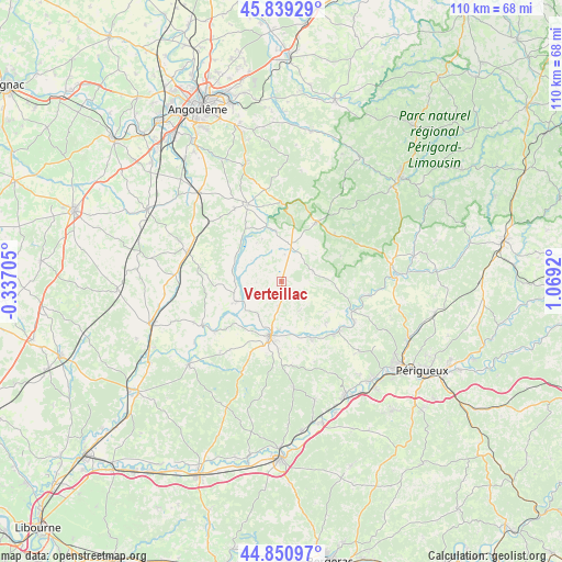
Verteillac GPS coordinates[2]
45° 20' 50.244" North, 0° 21' 57.852" East
| Map corner | latitude | longitude |
|---|---|---|
| Upper-left | 45.83929°, | -0.33705° |
| Center: | 45.34729°, | 0.36607° |
| Lower-right: | 44.85097°, | 1.0692° |
| Map W x H: | 109.9×109.9 km | = 68.3×68.3mi |
| max Lat: | 51.07786° ⇑75.8% North |
| Verteillac: | 45.34729° |
| min Lat: | ⇓24.2% South 41.3874° |
| min Long | Verteillac | max Long |
| -5.08615° | 0.36607° | 9.52242° |
| W 25.4%⇐ | ⇒74.6% E |
Elevation
Elevation of Verteillac is 130 m = 427 ft, and this is 63.7 m = 209 ft below average elevation for this country.
| Max E: |
2333 m = 7654 ft | 50.5% |
| Avg. | 193.7 m = 635 ft | |
| Verteillac | 130 m = 427 ft | |
Min E: |
-1 m = -3 ft | 49.5% |
See also: France elevation on elevation.city.
Geographical zone
Verteillac is located in North temperate zone (between Tropic of Cancer and the Arctic Circle). Distance of this North polar circle is 2359 km =1465.8 mi to North.| Distance of | km | miles | from Verteillac |
|---|---|---|---|
| North Pole | 4964.9 | 3085 | to North |
| Arctic Circle | 2359 | 1465.8 | to North |
| Tropic Cancer | 2436.2 | 1513.8 | to South |
| Equator | 5042.1 | 3133 | to South |


Nearby cities:
15 places around Verteillac: (largest is in red/bold)
• Allemans
8.8 km =5.5 mi,  215°
215°
• Bourdeilles
17.5 km =10.9 mi,  99°
99°
• Celles
6.7 km =4.2 mi,  146°
146°
• Grand-Brassac
11.6 km =7.2 mi,  127°
127°
• Lisle
16.3 km =10.1 mi,  117°
117°
• Mareuil
13.2 km =8.2 mi,  29°
29°
• Montagrier
12.2 km =7.6 mi, 134°
• Ribérac
11.1 km =6.9 mi,  193°
193°
• Saint-Martin-de-Ribérac
12.7 km =7.9 mi, 185°
• Saint-Privat-des-Prés
17.2 km =10.7 mi, 222°
• Saint-Séverin
9.7 km =6 mi,  249°
249°
• Tocane-Saint-Apre
14.6 km =9.1 mi,  135°
135°
• Vanxains
15.9 km =9.9 mi,  204°
204°
• Villebois-Lavalette
16.4 km =10.2 mi,  336°
336°
• Villetoureix
9.4 km =5.8 mi,  181°
181°
Sources, notices
• [Note1] Compared only with cities in France existing in our database
• [Src1] Map data: © OpenStreetMap contributors (CC-BY-SA)
• [Src2] Other city data from geonames.org with taken over terms of usage.
• [Src3] Geographical zone / Annual Mean Temperature by Robert A. Rohde @ Wikipedia
